 Rock
Rock Aggregate
 Cement
 Concrete
 Soil
Soil Steel
Steel Bitumen/Asphalt
 Security Survey Equipment
 General Items

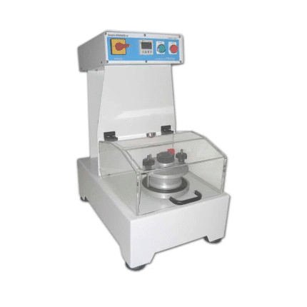
AZA 1040 PLANIMETER
- Precision instrument for measuring 2D area from maps/plans
- Suitable for civil, survey, GIS, & agricultural use
- Available in manual and digital variants
- High accuracy in irregular shape measurement
- Lightweight, compact, and durable build
- Easy-to-read dial or digital display
- Works on paper maps, blueprints, and tracing sheets
- Used by surveyors, engineers, architects, and students
Description
The Planimeter from Azalab is a precision instrument designed for measuring the area of two-dimensional shapes on paper maps, plans, charts, or diagrams. Widely used in surveying, cartography, civil engineering, architecture, and geographic information systems (GIS), it is essential for anyone needing fast, reliable, and repeatable area calculations — especially when dealing with irregular or freeform shapes.
Traditional measuring tools fail when it comes to complex figures or curved boundaries. This is where a planimeter excels. Whether you’re working with land use maps, agricultural plots, hydraulic layouts, or mechanical schematics, the Azalab Planimeter makes calculating enclosed areas simple, accurate, and efficient.
The Azalab Planimeter is available in two variants:
-
Manual (Polar) Planimeter:
-
Features a tracing arm, pivot, and mechanical dial.
-
Operated by manually tracing the perimeter of a shape.
-
The dial reads out the area based on the path traced.
-
-
Digital Planimeter:
-
Includes an LCD screen, electronic sensor, and internal calculator.
-
Measures area automatically and provides instant readouts in multiple units (cm², m², acres, hectares).
-
Often includes memory functions, conversion tools, and calibration settings.
-
Both models are compact, lightweight, and designed for tabletop or drafting use. They are compatible with standard paper maps, tracing sheets, blueprints, or any planar surface. The digital version is battery-operated, while the manual model is entirely mechanical and does not require power — perfect for use in remote areas or fieldwork setups.
The planimeter’s primary advantage lies in its ability to compute areas without the need for grid lines, mathematical approximations, or software tools. Simply place it at the boundary and trace around the desired area — the device does the rest. This makes it a trusted tool in industries where precision and speed are critical.
Field professionals use the planimeter to calculate:
-
Plot areas on cadastral maps
-
Water body extents on hydrographic maps
-
Floor plans and elevations in construction drawings
-
Agricultural field sizes from satellite printouts
-
Drainage and contour areas in topographic surveys
Students and researchers benefit from learning how to use a planimeter to develop spatial awareness and grasp measurement techniques before moving on to more advanced digital mapping platforms.
Durability is another key aspect of the Azalab Planimeter. It is built with high-quality materials to ensure longevity and resistance to wear, even after thousands of tracing cycles. The mechanical model uses hardened steel points and brass dials, while the digital version uses ABS casing and sensitive optical encoders.
To learn more about using planimeters or integrating them into GIS workflows, professionals can refer to standard guides published by USGS, Survey of India, or even international universities through platforms like nptel.ac.in or gisgeography.com.
In summary, the Azalab Planimeter is a practical and reliable tool for area measurement in both field and office environments. Whether you’re a seasoned surveyor or a student working on map interpretation, this tool ensures precise measurement of irregular shapes without the need for software, grids, or approximations.
Specifications:
| Feature | Manual Planimeter | Digital Planimeter |
|---|---|---|
| Operation | Mechanical tracing arm | Electronic with LCD display |
| Measurement Range | Up to 1000 cm² (expandable) | Multi-unit (cm², m², acres) |
| Accuracy | ±1% | ±0.2% to ±0.5% |
| Power Requirement | None | Battery operated |
| Material | Steel, brass | ABS plastic, metal stylus |
| Weight | Approx. 300–500g | Approx. 200–400g |
| Application | Maps, blueprints, diagrams | Same as manual + memory |
| Usage Fields | Survey, GIS, engineering | Survey, GIS, civil, planning |
Frequently Asked Questions (FAQ):
Q1: What is a planimeter used for?
A: A planimeter is used to measure the area of a two-dimensional shape on a flat surface like a map or drawing.
Q2: How does a planimeter work?
A: By tracing the perimeter of a shape, it calculates the enclosed area using mechanical or digital computation.
Q3: Is the digital version more accurate than the manual?
A: Yes, digital planimeters generally offer higher accuracy and faster readings.
Q4: Can it be used on any surface?
A: Yes, as long as the surface is flat and the figure is drawn to scale, the planimeter can be used.
Q5: Is calibration required?
A: Manual planimeters usually require scale conversion manually. Digital models may offer built-in calibration modes.
Additional information
| Operation |
Mechanical tracing arm |
|---|---|
| Measurement Range |
Up to 1000 cm² (expandable) |
| Accuracy |
±1% |
| Power Requirement |
None |
You may also like…
Abrasion Testing Machine for Glazed Tiles (AZA 1261)

Abrasion Testing Machine for Glazed Tiles (AZA 1262)

ABS Braking System Training Board Simulator (Model AZA1245)
Related products
AZA 1019 SCAFFOLD POLY CLIP
AZA 1020 ROUND POST HOLE FORM
AZA 1022 CORNER GUARD
AZA 1023 IMPALEMENT SAFETY COVERS
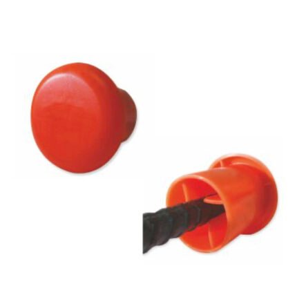
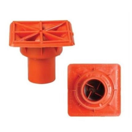
AZA 1024 PROTECTIVE CAPS FOR REBAR, PIPE, BOLTS
- Heavy-duty protective caps for rebar, pipe, and bolts
- Prevents injuries, corrosion, and damage on site
- Bright color enhances site visibility and safety
- Made from durable, weather-resistant plastic or rubber
- Available in multiple sizes and fits securely
- Compliant with OSHA and construction safety standards
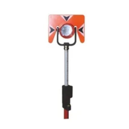
AZA 1036 PRISM WITH POLE
- Complete prism and pole assembly for total station use
- High-accuracy prism with silver-coated reflective surface
- Telescopic pole with metric graduations (up to 5 m)
- Adjustable target height for stakeout and offsetting
- Integrated bubble level for vertical alignment
- Compatible with Leica, Topcon, Sokkia total stations
- Durable housing with weather-resistant seals
- Ideal for land surveying, layout, and construction
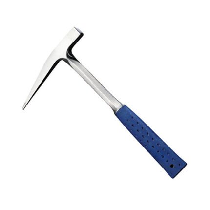
AZA 1041 GEOLOGICAL HAMMER
- Forged steel head for long-lasting durability
- Ideal for geologists, students & fossil hunters
- Anti-slip rubber handle for better grip
- Balanced weight for reduced hand fatigue
- Chisel & pointed tip options for varied tasks
- Shock-absorbing design minimizes vibrations
- Suitable for field, excavation & academic use
- Resistant to corrosion, wear & impact
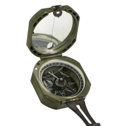
AZA 1042 BRUNTON COMPASS
- Precision magnetic needle with fast settling
- Includes clinometer for measuring angles
- Designed for geologists, surveyors, and engineers
- Rugged aluminum casing with mirror sighting
- Adjustable declination for accurate bearings
- Ideal for structural geology & mapping tasks
- Lightweight, portable, and shock-resistant
- Used widely in academic & fieldwork settings
