 Rock
Rock Aggregate
 Cement
 Concrete
 Soil
Soil Steel
Steel Bitumen/Asphalt
 Security Survey Equipment
 General Items
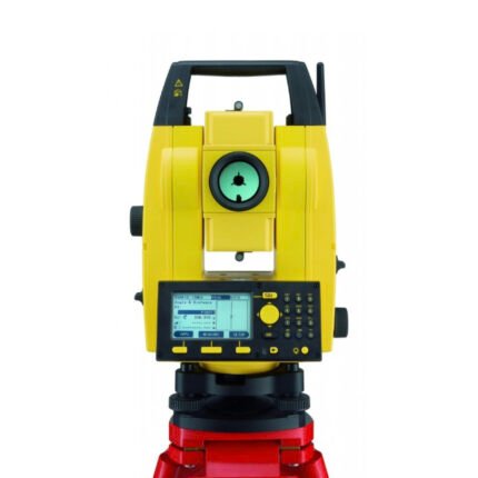
AZA 1029 TOTAL STATION BUILDER
- High-accuracy electronic total station for construction
- Ideal for layout, leveling, and boundary marking
- Long-range EDM up to 5,000 m with prism
- Dual-axis compensator ensures angle accuracy
- Built-in storage, USB, and Bluetooth options
- Easy-to-read LCD with alphanumeric keypad
- Supports coordinate geometry and stakeout
- Rugged, weatherproof design for field conditions
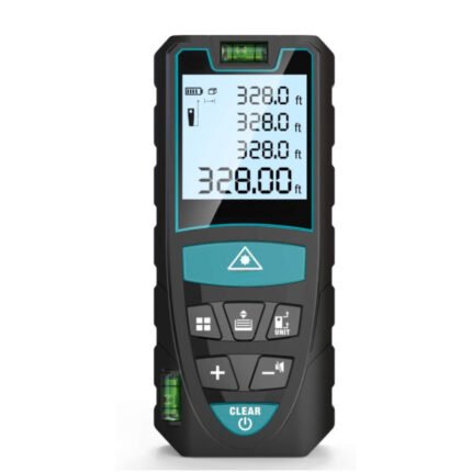
AZA 1030 LASER DISTANCE METER
- Instant digital measurement up to 100 meters
- Accurate to ±1.5 mm with fast response time
- Measures distance, area, volume, and Pythagorean
- Backlit LCD for easy viewing indoors/outdoors
- Compact, pocket-sized, and rechargeable
- Ideal for builders, surveyors, and interior designers
- Stores multiple readings with memory function
- Durable, dustproof, and splash-resistant
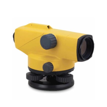
AZA 1031 AUTOMATIC LEVEL
- Auto leveling via magnetic damping compensator
- 24x–32x magnification for long-range visibility
- ±2.5 mm accuracy over 1 km double-run leveling
- Waterproof and dust-resistant rugged design
- Ideal for civil engineering, roads, buildings, and layout
- Easy horizontal angle measurement with 360° scale
- Tripod and leveling staff compatible
- Carrying case and adjustment tools included

AZA 1032 AUTOMATIC LEVEL

AZA 1033 AUTOMATIC LEVEL
- Precision leveling instrument for construction & surveying
- Magnetic damping for fast, stable readings
- Reliable optics with 20x–32x magnification options
- Ideal for land survey, building layout & road work
- Built-in compensator for auto horizontal alignment
- Durable, weather-resistant build for field use
- Easy to set up with tripod mount compatibility
- Smooth focusing with fine-tuning adjustment knobs

AZA 1034 LEVELLING STAVES
- High-visibility staff for elevation & height measurements
- Telescopic design for easy transport and storage
- Graduated in metric/imperial units for accuracy
- Compatible with all leveling instruments
- Lightweight aluminum or fiberglass construction
- Ideal for civil, land, and construction surveyors
- Lockable sections for stability during use
- Weather-resistant finish for outdoor performance
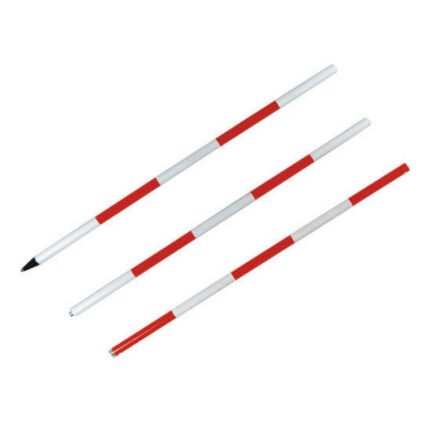
AZA 1035 RANGE POLE
- Used for GPS, total station, and alignment in land surveying
- Telescopic, lightweight aluminum or fiberglass build
- Available in multiple section lengths (2m to 5m)
- High-visibility color for long-distance visibility
- Precision tips and bubble levels for accurate positioning
- Compatible with prisms, GPS receivers & targets
- Sturdy locking mechanisms ensure pole stability
- Ideal for boundary marking and control points
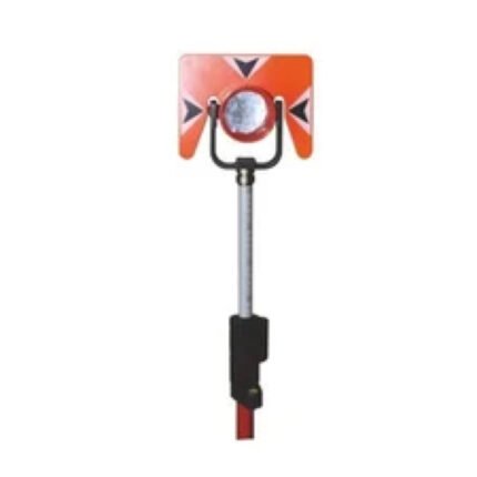
AZA 1036 PRISM WITH POLE
- Complete prism and pole assembly for total station use
- High-accuracy prism with silver-coated reflective surface
- Telescopic pole with metric graduations (up to 5 m)
- Adjustable target height for stakeout and offsetting
- Integrated bubble level for vertical alignment
- Compatible with Leica, Topcon, Sokkia total stations
- Durable housing with weather-resistant seals
- Ideal for land surveying, layout, and construction
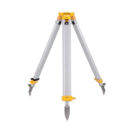
AZA 1037 ALUMINUM TRIPOD
- Lightweight aluminum tripod for field instruments
- Ideal for surveying, mapping, and construction layout
- Extendable legs with quick clamps for easy setup
- Stable base with pointed feet for all terrains
- Compatible with auto levels, total stations, lasers
- Includes shoulder strap or carrying handle
- Adjustable height: typically up to 160 cm
- Durable, rust-resistant design for outdoor use
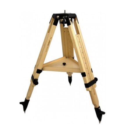
AZA 1038 WOODEN TRIPOD
- Heavy-duty wooden tripod for precise fieldwork
- Excellent stability and minimal vibration
- Ideal for total stations, theodolites, auto levels
- Adjustable legs with locking clamps
- Durable hardwood with weather-resistant coating
- Wide stance and pointed metal feet for grip
- Compatible with 5/8” x 11 thread instruments
- Preferred by surveyors, engineers, geologists

AZA 1039 GPS SYSTEM
- High-precision GPS system for professional use
- Ideal for land survey, GIS, mapping, and navigation
- Real-time positioning with multi-satellite support
- Integrated display and data logging
- Supports GNSS: GPS, GLONASS, Galileo, BeiDou
- Long battery life with rugged, waterproof design
- High signal sensitivity in remote areas
- Compatible with external software and data transfer

AZA 1040 PLANIMETER
- Precision instrument for measuring 2D area from maps/plans
- Suitable for civil, survey, GIS, & agricultural use
- Available in manual and digital variants
- High accuracy in irregular shape measurement
- Lightweight, compact, and durable build
- Easy-to-read dial or digital display
- Works on paper maps, blueprints, and tracing sheets
- Used by surveyors, engineers, architects, and students
