
 Rock
Rock Aggregate
 Cement
 Concrete
 Soil
Soil Steel
Steel Bitumen/Asphalt
 Security Survey Equipment
 General Items
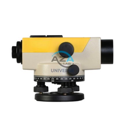
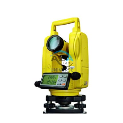
AZA 1031 AUTOMATIC LEVEL
- Auto leveling via magnetic damping compensator
- 24x–32x magnification for long-range visibility
- ±2.5 mm accuracy over 1 km double-run leveling
- Waterproof and dust-resistant rugged design
- Ideal for civil engineering, roads, buildings, and layout
- Easy horizontal angle measurement with 360° scale
- Tripod and leveling staff compatible
- Carrying case and adjustment tools included
Description
The Automatic Level, also known as an auto level or optical level, is a staple tool in modern surveying, construction layout, and civil engineering projects. Built for long-term accuracy, the Azalab Automatic Level is designed to streamline elevation measurements and enable reliable benchmarking even in rugged outdoor conditions.
At the heart of this instrument lies a magnetic damping compensator, which automatically corrects minor tilts and vibrations, ensuring a stable and level line of sight. This self-leveling mechanism eliminates human error and saves setup time, making it ideal for high-precision work over long distances.automatic level, leveling instrument, survey level tool, construction leveling device, site leveling equipment.
With optical magnification ranging between 24x and 32x, the Azalab auto level offers a clear, sharp image of the leveling staff, even at distances of up to 100 meters or more. The superior lens quality allows users to read graduations on leveling staves with confidence, ensuring ±2.5 mm or better accuracy per kilometer of double-run leveling — more than sufficient for road construction, pipeline installation, and drainage layout.
The Azalab Automatic Level features a 360-degree horizontal circle, allowing for horizontal angle measurements. The fine-tuning knobs provide smooth rotation and locking, enabling consistent targeting and layout alignment across large-scale sites.
Built to withstand the elements, the unit comes encased in a water-resistant, shockproof housing, making it reliable for use in dusty, wet, or vibration-prone environments. The IP-rated casing keeps out moisture and particles that could affect optical clarity or mechanism integrity.
Installation is straightforward: attach the instrument to a standard surveying tripod, roughly level the unit using the bubble vial, and let the internal compensator finalize the leveling automatically. The tool is compatible with standard 5/8″ tripod threads and works seamlessly with metric or imperial leveling staves.
The Azalab automatic level is widely used in:
-
Roadwork and highway design
-
Building foundation and floor leveling
-
Land surveying and boundary determination
-
Drainage and canal gradient planning
-
Construction of bridges and culverts
All Azalab levels are factory-calibrated and shipped with a rugged carrying case, plumb bob, lens cleaning cloth, and adjustment tools. The model can be easily recalibrated on-site using the built-in adjustment screws, ensuring long-term performance even after transport or rough handling.
This automatic level offers exceptional value in terms of durability, usability, and performance — a must-have for any civil engineer, site supervisor, architect, or surveyor. The intuitive operation makes it suitable for both professionals and students in geotechnical or civil engineering programs.
To learn more about leveling standards, accuracy calibration, and surveying practices, users may explore expert technical resources available on topconpositioning.com, leica-geosystems.com, or sokkia.com, which provide industry-grade tutorials and guidance.
Specifications:
| Feature | Specification |
|---|---|
| Telescope Magnification | 24x / 28x / 32x (model-dependent) |
| Objective Aperture | 36 mm |
| Minimum Focus Distance | 0.3 – 0.5 m |
| Accuracy | ±2.0 to ±2.5 mm per 1 km double-run leveling |
| Compensator Range | ±15 arc minutes |
| Horizontal Circle | 360° graduated circle |
| Dust/Water Protection | IP54 / IP65 rated (model-dependent) |
| Tripod Mount | 5/8 inch standard thread |
| Weight | Approx. 1.5 – 2.5 kg |
| Accessories Included | Carrying case, tools, lens cloth, manual |
Frequently Asked Questions (FAQ):
Q1: Is the automatic level difficult to use for beginners?
A: Not at all. It levels itself automatically once roughly aligned, making it user-friendly for beginners and professionals alike.
Q2: How accurate is it for construction leveling?
A: It offers ±2.5 mm or better per kilometer of leveling — suitable for most site and layout tasks.
Q3: What accessories do I need?
A: A standard tripod and leveling staff are essential for operation. Most models come with a case, manual, and adjustment tools.
Q4: Can it be used in rainy or dusty environments?
A: Yes, the unit is built with water and dust-resistant housing for tough site conditions.
Q5: Do I need to recalibrate it often?
A: Periodic calibration is advisable, especially after travel or impact, but the factory setting remains stable with proper care.
Additional information
| Telescope Magnification |
24x / 28x / 32x (model-dependent) |
|---|---|
| Objective Aperture |
36 mm |
| Minimum Focus Distance |
0.3 – 0.5 m |
| Accuracy |
±2.0 to ±2.5 mm per 1 km double-run leveling |
Related products

AZA 1039 GPS SYSTEM
- High-precision GPS system for professional use
- Ideal for land survey, GIS, mapping, and navigation
- Real-time positioning with multi-satellite support
- Integrated display and data logging
- Supports GNSS: GPS, GLONASS, Galileo, BeiDou
- Long battery life with rugged, waterproof design
- High signal sensitivity in remote areas
- Compatible with external software and data transfer
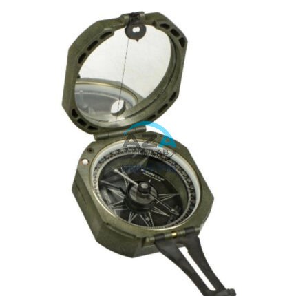
AZA 1042 BRUNTON COMPASS
- Precision magnetic needle with fast settling
- Includes clinometer for measuring angles
- Designed for geologists, surveyors, and engineers
- Rugged aluminum casing with mirror sighting
- Adjustable declination for accurate bearings
- Ideal for structural geology & mapping tasks
- Lightweight, portable, and shock-resistant
- Used widely in academic & fieldwork settings
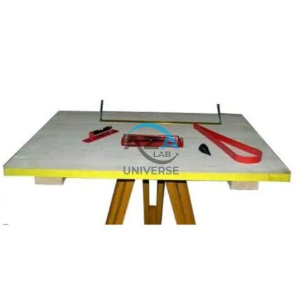
AZA 1044 PLANE TABLE SET
- Complete plane table set for surveying and mapping
- Ideal for topographic work, site planning, and field layout
- Includes drawing board, alidade, tripod & accessories
- Weather-resistant wooden board with smooth surface
- Collapsible, stable tripod stand with adjustable height
- Used by civil engineers, geologists, and students
- Durable and easy to transport
- Compatible with standard drawing sheets and maps