 Rock
Rock Aggregate
 Cement
 Concrete
 Soil
Soil Steel
Steel Bitumen/Asphalt
 Security Survey Equipment
 General Items

AZA 1044 PLANE TABLE SET
- Complete plane table set for surveying and mapping
- Ideal for topographic work, site planning, and field layout
- Includes drawing board, alidade, tripod & accessories
- Weather-resistant wooden board with smooth surface
- Collapsible, stable tripod stand with adjustable height
- Used by civil engineers, geologists, and students
- Durable and easy to transport
- Compatible with standard drawing sheets and maps
Description
PLANE TABLE SET
The Plane Table Set from Azalab is a traditional yet powerful tool used in field surveying, topographic mapping, and civil engineering site planning. Designed to offer simplicity, precision, and direct data plotting, this set is widely used by surveyors, geologists, architects, and engineering students alike.plane table set, field survey equipment, topographic mapping tool, site layout instrument, portable mapping kit.
A plane table survey allows the operator to plot details directly onto paper in the field, minimizing errors and reducing time spent in transferring measurements later. Unlike modern total stations or electronic data collectors, the plane table method offers a hands-on and visual approach, ideal for educational settings and outdoor fieldwork where a clear picture of the terrain is needed in real time.plane table set, field survey equipment, topographic mapping tool, site layout instrument, portable mapping kit.
The Azalab Plane Table Set includes all essential components:
-
A smooth-finished wooden board for secure sheet mounting
-
A collapsible, adjustable tripod stand for stability on uneven terrain
-
A telescopic alidade with sighting vanes for accurate angular measurements
-
Spirit level, plumbing fork, and clamps for leveling and alignment
The drawing board is made from seasoned, warp-resistant wood, polished to offer a frictionless surface for easy drafting. Its large size accommodates standard drawing sheets or mapping paper, and it is equipped with strong clamps to secure maps firmly even in breezy conditions.
The alidade, a crucial part of this surveying system, is used to sight distant points and draw precise rays on the map sheet. It typically includes a ruler base and sight vanes or a telescope for improved accuracy. By aligning the alidade and using direct ray plotting, users can quickly construct maps, determine positions, and record natural or man-made features.
The tripod features adjustable legs and a firm central mount to hold the board steady. Whether on soft soil or rocky ground, the tripod ensures your working surface stays level — aided further by the included spirit level and plumbing fork to orient the board directly over survey points.
The Azalab plane table set is valued for its portability and ruggedness, making it ideal for use in remote terrain, construction sites, or educational field trips. It requires no batteries, making it completely manual and reliable in off-grid areas. It’s also a preferred choice in hydrographic surveys, contour mapping, and site layout planning, where direct plotting is faster and more intuitive than digital processing.
While digital tools dominate modern surveying, plane table sets remain relevant due to their cost-efficiency, ease of use, and educational benefits. They help students learn the fundamentals of coordinate plotting, triangulation, intersection, and resection methods.
For additional study or official techniques related to plane table surveying, you can refer to practical manuals provided by the Survey of India (surveyofindia.gov.in) or fieldwork guides from academic institutions like IITs or NPTEL, which emphasize hands-on learning through traditional surveying methods.
In summary, the Azalab Plane Table Set is a dependable, field-proven tool for hands-on mapping and real-time data plotting. With its sturdy construction, complete set of accessories, and user-friendly setup, it continues to be a trusted choice for professionals and students alike. Whether you’re charting contours on hilly terrain or planning a building site layout, this versatile set delivers precision and efficiency in every use.
Specifications:
| Feature | Description |
|---|---|
| Board Material | Polished, warp-resistant wood |
| Board Size | Approx. 60 cm x 75 cm |
| Tripod | Collapsible, adjustable-height metal stand |
| Alidade | Telescopic with sighting vanes or telescope |
| Spirit Level | Included for board leveling |
| Plumbing Fork | Provided for accurate centering |
| Usage | Field survey, mapping, civil layout |
| Weight | Varies (typically 6–10 kg total) |
| Accessories | Drawing clips, screws, protective case |
| Application | Educational, civil engineering, geology |
Frequently Asked Questions (FAQ):
Q1: What is a plane table used for?
A: It’s used for surveying and mapping in the field by plotting features directly onto paper using sighting and measurement.
Q2: Is it suitable for professional work?
A: Yes, it’s used in both academic and professional settings like site layout, topographic mapping, and contour surveys.
Q3: Can students use it for practical fieldwork?
A: Absolutely! It’s widely used in civil engineering and geology field training to teach manual mapping and survey techniques.
Q4: Does it include all necessary accessories?
A: Yes, the set includes the drawing board, tripod, alidade, plumbing fork, level, and required clamps.
Q5: How is it better than digital instruments?
A: While not as fast as digital tools, it is cost-effective, reliable, and great for teaching fundamental surveying concepts.
Additional information
| Board Material |
Polished, warp-resistant wood |
|---|---|
| Board Size |
Approx. 60 cm x 75 cm |
| Tripod |
Collapsible, adjustable-height metal stand |
| Alidade |
Telescopic with sighting vanes or telescope |
You may also like…

Air Bag Trainer (Model AZA1246)

AZA 0809 MORTOR MIXER

AZA 0810 FULLY AUTOMATIC MORTAR MIXER
- Fully automatic mortar mixing system
- PLC-based programmable controls
- Dual-speed planetary motion for uniform mix
- Stainless steel mixing bowl and blades
- Follows ASTM and IS testing standards
- Ideal for labs, R&D, and educational setups

AZA 0955 MIXER WITH HEATING JACKET
- Controlled Heating: Integrated jacket maintains precise, uniform temperatures during mixing.
- Homogeneous Blending: Ensures thorough and consistent mixing of viscous materials.
- Lab-Scale Precision: Ideal for preparing asphalt, bituminous, and other heated samples.
- Robust Construction: Durable design for demanding laboratory environments.
- Versatile Application: Suitable for mix design, quality control, and research

AZA 0960 TRAVELLING BEAM DEVICE
- Pavement Roughness Assessment: Accurately measures longitudinal unevenness of road surfaces.
- Riding Quality Indicator: Provides critical data for evaluating pavement serviceability and comfort.
- Robust & Portable: Durable construction, designed for efficient field measurements.
- Consistent Results: Ensures repeatable measurements for effective quality control.
- Essential for QC & Maintenance: Key tool for new construction validation and identifying rehabilitation needs

AZA 1016 METALLURGICAL INVERTED MICROSCOPE
- AZA 1016 Metallurgical Inverted Microscope: For precise inspection of opaque materials.
- Inverted design ideal for large, heavy, or irregular samples.
- High-quality infinity-corrected LWD metallurgical objectives (20x-1000x).
- Powerful Epi-Illumination (Halogen/LED) with Koehler setup.
- Robust mechanical stage and precise coaxial focusing.
- Trinocular head for camera attachment, enabling image capture.
- Essential for metallography, quality control, and R&D in materials science.
- Manufactured with durable die-cast aluminum stand
Related products
AZA 1020 ROUND POST HOLE FORM
AZA 1021 SQUARE HOLE FORM
AZA 1023 IMPALEMENT SAFETY COVERS

AZA 1025 SAFETY HELMET

AZA 1026 SAFETY CONE
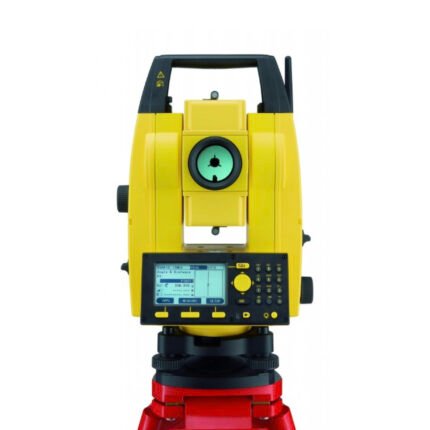
AZA 1029 TOTAL STATION BUILDER
- High-accuracy electronic total station for construction
- Ideal for layout, leveling, and boundary marking
- Long-range EDM up to 5,000 m with prism
- Dual-axis compensator ensures angle accuracy
- Built-in storage, USB, and Bluetooth options
- Easy-to-read LCD with alphanumeric keypad
- Supports coordinate geometry and stakeout
- Rugged, weatherproof design for field conditions

AZA 1032 AUTOMATIC LEVEL

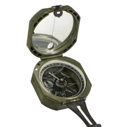
AZA 1043 PRISMATIC COMPASS
- High-precision prismatic compass for field use
- Ideal for land survey, mapping, and geology work
- Optical prism for accurate angle readings
- Sighting slit for directional alignment
- Liquid-filled capsule for steady needle movement
- Lightweight metal body with protective lid
- Marked in degrees and mils
- Used by engineers, surveyors, hikers, and geologists
