 Rock
Rock Aggregate
 Cement
 Concrete
 Soil
Soil Steel
Steel Bitumen/Asphalt
 Security Survey Equipment
 General Items
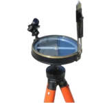
PLANE TABLE SET AZA1044
The Plane Table Set AZA1044 from Azalab is a classic and highly effective field surveying and mapping instrument used for topographic surveys, site layout, and civil engineering planning. Known for its simplicity, accuracy, and real-time plotting capability, this set is widely adopted by surveyors, civil engineers, geologists, architects, and engineering students for both professional and academic fieldwork.
Plane table surveying allows measurements and observations to be plotted directly onto paper at the survey site, eliminating transcription errors and significantly reducing post-field processing time. Unlike electronic instruments, this manual method provides a visual and intuitive understanding of terrain, making it especially valuable for education, reconnaissance surveys, and remote-area mapping.
Description
Complete Field Survey Solution
The Azalab Plane Table Set AZA1044 is supplied as a complete portable mapping kit, including all essential accessories required for accurate field operation:
-
Smooth-finished wooden drawing board with sheet-holding clamps
-
Collapsible adjustable tripod stand for stability on uneven ground
-
Telescopic alidade with sighting vanes or telescope for precise ray plotting
-
Spirit level for accurate board leveling
-
Plumbing fork (U-fork) for centering over ground points
-
Fasteners, clamps, and protective storage accessories
The drawing board is manufactured from seasoned, warp-resistant polished wood, providing a flat, friction-free surface suitable for detailed drafting. Strong clamps ensure mapping sheets remain secure even under windy outdoor conditions.
Accuracy Through Direct Plotting
The alidade is the core working component of the plane table system. By sighting distant points and drawing rays directly on the map sheet, users can perform radiation, intersection, resection, and traversing methods efficiently. This approach allows natural features, boundaries, and structures to be recorded accurately in real time.
The adjustable tripod, combined with the spirit level and plumbing fork, ensures proper leveling and precise orientation of the board over survey stations. This stability is critical for maintaining angular accuracy during field operations.
Rugged, Portable & Power-Free
Designed for outdoor durability and ease of transport, the AZA1044 Plane Table Set is suitable for use in remote terrain, construction sites, and educational field camps. As a fully manual system, it requires no electricity or batteries, making it dependable in off-grid environments where electronic instruments may be impractical.
Despite advances in digital surveying technology, plane table surveying remains relevant due to its cost-effectiveness, reliability, and educational value. It plays a vital role in teaching survey fundamentals such as triangulation, coordinate plotting, and contour mapping.
Applications
-
Topographic and contour mapping
-
Civil engineering site layout and planning
-
Geological field mapping
-
Educational and training field surveys
-
Hydrographic and reconnaissance surveys
-
Rural and remote-area mapping
Specifications
| Feature | Specification |
|---|---|
| Model | AZA1044 |
| Board Material | Polished, warp-resistant wood |
| Board Size | Approx. 60 cm × 75 cm |
| Tripod | Collapsible, adjustable-height metal stand |
| Alidade | Telescopic with sighting vanes / telescope |
| Spirit Level | Included |
| Plumbing Fork | Included |
| Weight | Approx. 6–10 kg (complete set) |
| Accessories | Drawing clips, screws, protective case |
| Usage | Field survey, mapping, civil layout |
| Application | Education, civil engineering, geology |
Frequently Asked Questions (FAQ)
Q1: What is the Plane Table Set AZA1044 used for?
It is used for field surveying and mapping by plotting features directly onto paper using sighting and angular measurements.
Q2: Is this suitable for professional surveying work?
Yes. It is widely used for site layout, topographic surveys, and contour mapping, as well as academic and training purposes.
Q3: Can students use this set for field practicals?
Absolutely. It is a standard instrument in civil engineering and geology field training programs.
Q4: Does the set include all necessary accessories?
Yes. The set includes the drawing board, tripod, alidade, spirit level, plumbing fork, and required clamps.
Q5: Why choose a plane table over digital instruments?
Plane table surveying is cost-effective, reliable, battery-free, and ideal for learning fundamental surveying principles and real-time mapping.
Key Highlights
-
Complete plane table set for surveying and mapping
-
Ideal for topographic work, site planning, and field layout
-
Includes drawing board, alidade, tripod, and accessories
-
Weather-resistant wooden board with smooth drafting surface
-
Collapsible and stable tripod with adjustable height
-
No power required — reliable in remote locations
-
Used by civil engineers, geologists, and students
-
Compatible with standard drawing sheets and maps
Model: AZA1044 – Plane Table Set by Azalab
Additional information
| Board Material |
Polished, warp-resistant wood |
|---|---|
| Board Size |
Approx. 60 cm x 75 cm |
| Tripod |
Collapsible, adjustable-height metal stand |
| Alidade |
Telescopic with sighting vanes or telescope |
You may also like…
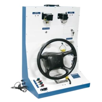
Air Bag Trainer AZA1246
The AZA1246 AZALAB Air Bag Trainer is a comprehensive educational training platform designed to demonstrate the structure, operation, diagnostics, and fault analysis of modern automotive airbag systems, also known as Supplemental Restraint Systems (SRS). Built using OEM automotive components, this trainer delivers a realistic learning experience while maintaining complete operational safety.
This system is ideally suited for automotive engineering colleges, ITIs, polytechnic institutes, vocational training centers, and service technician programs, enabling both theoretical instruction and hands-on diagnostics practice.
FULLY AUTOMATIC MORTAR MIXER AZA0805
Built to comply with IS:516, IS:1199, ASTM C192, and other relevant standards, the AZA0805 ensures accurate and reliable mixing performance. Ideal for QA/QC laboratories, construction material testing centers, academic institutions, and R&D facilities, this mixer offers stable operation, high durability, and ease of maintenance.
Laboratory concrete mixer, concrete mixer, AZA0805 mixer, cement testing mixer, concrete testing equipment.
The AZA0805 provides dependable, standardized mixing performance for concrete specimens used in strength testing, durability studies, and trial mix development. Its heavy-duty design, stainless steel drum, and controlled mixing action ensure uniform distribution of aggregates, cement, and water.
This equipment is essential for concrete testing laboratories, cement manufacturers, academic engineering labs, and government material testing centers. It adheres to IS & ASTM standards, ensuring accurate and reproducible mixing suitable for compressive and flexural strength testing.
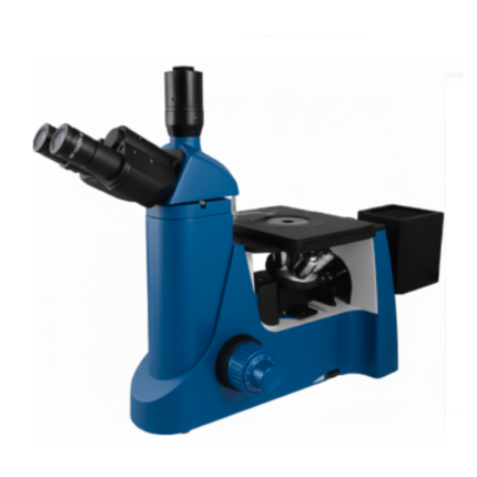
METALLURGICAL INVERTED MICROSCOPE AZA1016
Key Advantages
- Inverted optical system for easy sample placement
- Ideal for large, heavy, or irregular samples
- Stable viewing plane for uniform focusing
- Reflected (Epi) illumination for opaque materials
- Safe operation with reduced risk of objective damage
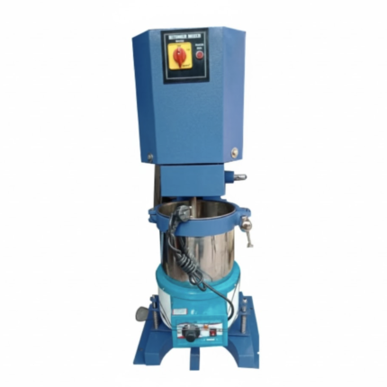
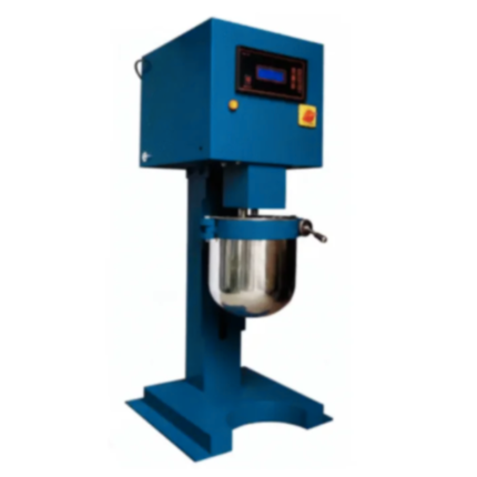
MIXER WITH HEATING JACKET AZA0955
The AZA0955 Mixer with Heating Jacket from AZALAB is a specialized laboratory apparatus engineered for the precise, uniform, and temperature-controlled mixing of materials that require elevated temperatures during blending. It is an essential instrument in civil engineering and highway material laboratories, particularly for the preparation of bituminous and asphalt mixes such as Hot Mix Asphalt (HMA).
By maintaining materials at a controlled and uniform temperature throughout the mixing process, the AZA0955 ensures optimal binder viscosity, thorough aggregate coating, and homogeneous sample preparation. This level of control is critical for producing accurate, repeatable, and representative laboratory specimens, which directly influence the reliability of asphalt mix design, quality control, and performance testing.
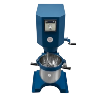
MORTOR MIXER AZA0804
Built to meet the rigorous requirements of IS:4031, IS:1727, and ASTM C305, the AZA0804 ensures your mortar mixes are prepared exactly as required for credible, repeatable laboratory results. It is widely used in construction material laboratories, cement manufacturing QC divisions, R&D centers, government-approved testing labs, and academic institutions.
This mixer, known commonly as a mortar mixer, cement mortar mixer, lab mortar mixer, AZA0804 mixer, is an essential machine for preparing standardized mortar samples used in cement testing across the industry.

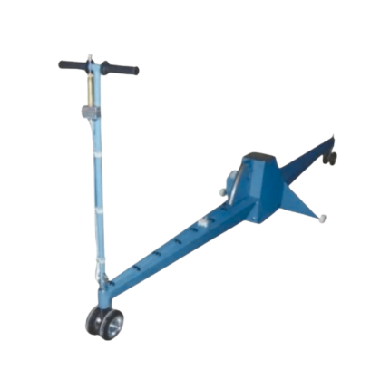
TRAVELLING BEAM DEVICE AZA0960
The AZA0960 Travelling Beam Device from AZALAB is a fundamental and widely accepted instrument for measuring longitudinal surface unevenness (roughness) of road pavements. It is extensively used by highway engineers, road contractors, consultants, and quality control laboratories across India for evaluating the riding quality and service condition of both newly constructed and existing roads.
Surface unevenness directly influences vehicle operating costs, passenger comfort, road safety, drainage performance, and pavement service life. The AZA0960 provides a reliable and cost-effective method for quantifying pavement roughness, enabling engineers to ensure compliance with specifications laid down by the Ministry of Road Transport & Highways (MoRTH) and the Indian Roads Congress (IRC).
Related products
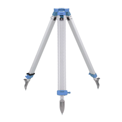
ALUMINUM TRIPOD AZA1037
AZA1037 Aluminum Tripod (Surveying & Construction Instrument Stand)
The AZA1037 Aluminum Tripod from Azalab is a high-precision, field-ready instrument stand engineered to provide maximum stability, portability, and durability for professional surveying and construction applications. It serves as a reliable mounting platform for auto levels, total stations, theodolites, rotary lasers, and mapping instruments, ensuring accurate measurements in demanding site conditions.
Lightweight & Corrosion-Resistant Construction
Manufactured from high-grade anodized aluminum alloy, the AZA1037 tripod offers an optimal balance between strength and weight. The corrosion-resistant finish makes it suitable for prolonged outdoor use, including dusty construction sites, uneven terrain, and damp environments, without compromising structural integrity or performance.
Despite its robust construction, the tripod remains lightweight, allowing easy handling and transportation between job locations.

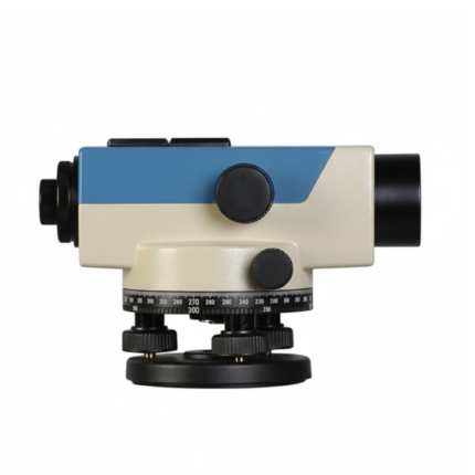
AUTOMATIC LEVEL AZA1032
AZA1032 Automatic Level (Self-Leveling Optical Level)
The AZA1032 Automatic Level is a precision self-leveling optical instrument designed for accurate height transfer, alignment, and leveling operations in construction, surveying, and civil engineering projects. Engineered for reliability, ease of use, and field durability, it delivers consistent performance on demanding job sites.
Automatic Self-Leveling Accuracy
At the core of the AZA1032 is a built-in compensator mechanism that automatically aligns the line of sight to a true horizontal plane. After rough leveling using the circular bubble vial, the compensator fine-tunes alignment instantly, eliminating manual errors and significantly reducing setup time.
This self-leveling system ensures stable readings even in environments affected by vibration or minor ground movement.
AUTOMATIC LEVEL AZA1033
AZA1033 Automatic Level (Auto Level / Self-Leveling Optical Level)
The AZA1033 Automatic Level is a high-precision optical surveying instrument engineered for accurate elevation measurement in construction, roadwork, and civil engineering projects. Designed to establish and verify horizontal planes over long distances, it is an essential tool for engineers, surveyors, and site supervisors who require speed, stability, and dependable accuracy.
Self-Leveling Accuracy with Built-in Compensator
Unlike manual leveling instruments, the AZA1033 features a self-leveling compensator system that automatically maintains a true horizontal line of sight. Once roughly leveled using the circular bubble vial, the internal compensator corrects minor tilts and vibrations instantly.
This mechanism significantly reduces setup time, eliminates operator error, and ensures stable readings even on uneven ground or vibration-prone sites
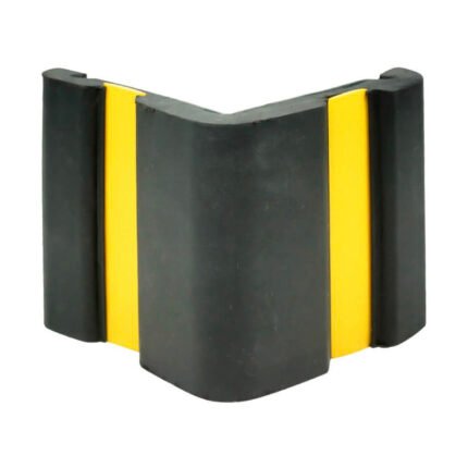
CORNER GUARD AZA1022
Wall & Edge Protection Solutions for Safety, Durability, and Aesthetics by Azalab
The AZA1022 Corner Guards are a practical, durable, and cost-effective solution for protecting wall edges and exposed corners from impact damage in both residential and commercial environments. Designed to prevent chipping, cracking, abrasion, and collision damage, these guards are especially essential in high-traffic areas where trolleys, carts, wheelchairs, forklifts, or vehicles are frequently in use.
Azalab’s AZA1022 range combines impact resistance, safety visibility, and clean aesthetics, ensuring long-term protection while maintaining the visual integrity of interior and exterior spaces.
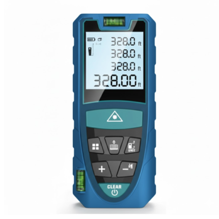
LASER DISTANCE METER AZA1030
AZA1030 Laser Distance Meter
The AZA1030 Laser Distance Meter is a compact, high-precision digital measuring instrument designed for fast, accurate, and efficient distance measurement across construction, interior design, surveying, and real estate applications. Replacing conventional tape measures, the AZA1030 delivers instant results at the push of a button while significantly reducing manual errors and site time.
Fast & Accurate Digital Measurement
Powered by advanced laser diode technology, the AZA1030 provides measurement accuracy up to ±1.5 mm, with model-dependent measuring ranges extending up to 100 meters. It supports multiple measuring functions, enabling professionals to capture complex dimensions quickly and reliably.
Measurement capabilities include:
-
Single and continuous distance measurement
-
Area and volume calculation
-
Indirect height and distance measurement (Pythagorean mode)
-
Minimum / maximum tracking
This makes AZA1030 ideal for layout planning, verification, and space assessment.
PLANIMETER AZA1040

SAFETY CONE AZA1026
High-Visibility Traffic & Site Safety Cone by Azalab
The AZA1026 Safety Cone is a versatile and essential safety device used for traffic control, hazard marking, and area demarcation across construction sites, roads, laboratories, parking areas, and industrial facilities. Designed for maximum visibility, durability, and ease of handling, AZA1026 provides reliable performance in both indoor and outdoor environments.
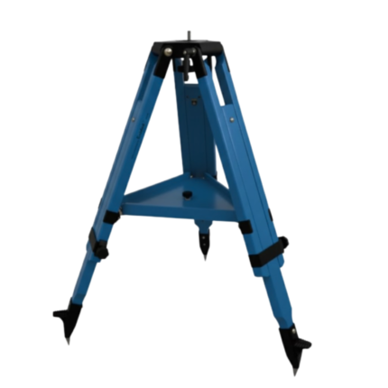
WOODEN TRIPOD AZA1038
Superior Stability with Natural Vibration Dampening
Unlike aluminum tripods, wooden tripods provide natural vibration absorption, making them the preferred choice for total stations, theodolites, laser scanners, and auto levels—especially for long-distance and high-accuracy measurements. The AZA1038 is manufactured from seasoned hardwood, carefully selected and treated to resist moisture, warping, and deformation, ensuring consistent performance in both dry and humid environments