
 Rock
Rock Aggregate
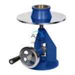 Cement
 Concrete
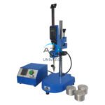 Soil
Soil Steel
Steel Bitumen/Asphalt
 Security Survey Equipment
 General Items
")
PLANIMETER AZA1040
The Planimeter AZA1040 from Azalab is a precision instrument designed for accurate measurement of two-dimensional areas on paper maps, plans, charts, drawings, and diagrams. It is widely used in surveying, cartography, civil engineering, architecture, town planning, agriculture, and GIS applications, particularly where irregular or curved boundaries must be measured reliably.
Conventional methods such as grid counting or manual calculation become inefficient and inaccurate when dealing with complex shapes. The AZA1040 Planimeter overcomes this limitation by allowing users to trace the perimeter of any closed figure, instantly converting the traced path into an accurate area measurement.
Description
Available Variants
Manual (Polar) Planimeter
-
Mechanical tracing arm with pivot point
-
Hardened tracing tip and precision dial mechanism
-
Area is calculated mechanically as the perimeter is traced
-
Requires no power supply, making it ideal for field use and remote locations
Digital Planimeter
-
Electronic sensor with LCD digital display
-
Automatic area computation with instant readouts
-
Supports multiple units such as cm², m², acres, and hectares
-
Includes memory, unit conversion, and calibration functions
-
Battery operated for portability
Both variants are compact, lightweight, and suitable for use on maps, blueprints, tracing sheets, satellite printouts, and engineering drawings.
Key Advantages
-
Measures irregular and free-form shapes with high accuracy
-
Eliminates the need for grid overlays or mathematical approximation
-
Fast, repeatable, and user-friendly operation
-
Suitable for both field and office environments
-
Durable construction ensures long service life
Typical Applications
-
Land parcel and plot area measurement
-
Agricultural field size calculation
-
Hydraulic and drainage layout analysis
-
Floor plans and architectural drawings
-
Contour and watershed studies
-
Educational training in surveying and GIS
Construction & Durability
The manual AZA1040 uses hardened steel components and precision brass dials for long-term mechanical accuracy.
The digital AZA1040 features a robust ABS housing with a sensitive electronic encoder and metal tracing stylus, designed for thousands of tracing cycles without performance degradation.
Specifications
| Feature | Manual Planimeter | Digital Planimeter |
|---|---|---|
| Model | AZA1040 (Manual) | AZA1040 (Digital) |
| Operation | Mechanical tracing | Electronic with LCD |
| Measurement Units | Scale dependent | cm², m², acres, hectares |
| Accuracy | ±1% | ±0.2% to ±0.5% |
| Power Requirement | Not required | Battery operated |
| Material | Steel & brass | ABS body, metal stylus |
| Weight | Approx. 300–500 g | Approx. 200–400 g |
| Application | Maps, drawings, diagrams | Same + memory storage |
Frequently Asked Questions (FAQ)
Q1: What is a planimeter used for?
It is used to measure the area of irregular two-dimensional shapes drawn on flat surfaces such as maps and plans.
Q2: How does the AZA1040 Planimeter work?
By tracing the boundary of a shape, the device converts the movement into an area calculation mechanically or digitally.
Q3: Is the digital version more accurate than the manual model?
Yes. Digital versions generally provide higher accuracy and faster readings.
Q4: Can it be used on any paper surface?
Yes, as long as the drawing is flat and properly scaled.
Q5: Is calibration required?
Manual models require scale factor conversion. Digital models offer built-in calibration modes.
Key Highlights
-
Precision instrument for 2D area measurement
-
Ideal for surveying, civil engineering, GIS, and agriculture
-
Available in manual and digital versions
-
Excellent accuracy for irregular shapes
-
Lightweight, durable, and easy to operate
-
Suitable for professionals, students, and research institutions
Model: AZA1040 – Azalab Planimeter
Additional information
| Operation |
Mechanical tracing arm |
|---|---|
| Measurement Range |
Up to 1000 cm² (expandable) |
| Accuracy |
±1% |
| Power Requirement |
None |
You may also like…
ABRASION TESTING MACHINE FOR GLAZED TILES AZA1262
The AZA LAB Abrasion Testing Machine for Glazed Tiles (AZA1262) is a robust, high-performance laboratory instrument engineered for precise and high-speed abrasion resistance testing of glazed ceramic tiles. Fully compliant with BIS 13630-11 and EN ISO 10545-7, this machine is designed to ensure reliable evaluation of tile durability under simulated real-world wear conditions.
With the capability to test up to four specimens simultaneously, the AZA1262 significantly improves testing efficiency while maintaining exceptional accuracy and repeatability—making it ideal for tile manufacturers, certification laboratories, and quality control departments
ABRASION TESTING MACHINE FOR GLAZED TILES AZA1261
The AZA LAB Abrasion Testing Machine for Glazed Tiles (AZA1261) is a precision-engineered laboratory instrument designed for the accurate determination of abrasion resistance in glazed ceramic tiles. Fully compliant with BIS 13630-11 and EN ISO 10545-7, this machine is essential for evaluating tile durability and surface wear performance in accordance with international quality standards.
The AZA1261 simulates real-world foot traffic and surface wear conditions, enabling manufacturers, testing laboratories, and quality control departments to verify that glazed tiles maintain their appearance, texture, and integrity even under high-traffic usage.
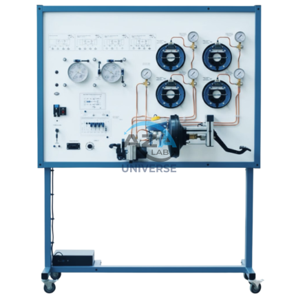
ABS BRAKING SYSTEM TRAINING BOARD SIMULATOR AZA1245
The AZA1245 AZALAB ABS Braking System Training Board Simulator is a fully functional automotive training platform designed to provide in-depth, hands-on understanding of Anti-lock Braking System (ABS) operation, diagnostics, and repair procedures. Built using real automobile components, this simulator enables students and technicians to study ABS structure, electronic control, hydraulic behavior, and fault diagnostics in a safe and controlled learning environment.
This training system is ideal for automotive training institutes, engineering colleges, technical schools, and service technician programs, supporting both instructional demonstrations and practical troubleshooting exercises.
Related products
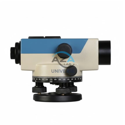
AUTOMATIC LEVEL AZA1033
AZA1033 Automatic Level (Auto Level / Self-Leveling Optical Level)
The AZA1033 Automatic Level is a high-precision optical surveying instrument engineered for accurate elevation measurement in construction, roadwork, and civil engineering projects. Designed to establish and verify horizontal planes over long distances, it is an essential tool for engineers, surveyors, and site supervisors who require speed, stability, and dependable accuracy.
Self-Leveling Accuracy with Built-in Compensator
Unlike manual leveling instruments, the AZA1033 features a self-leveling compensator system that automatically maintains a true horizontal line of sight. Once roughly leveled using the circular bubble vial, the internal compensator corrects minor tilts and vibrations instantly.
This mechanism significantly reduces setup time, eliminates operator error, and ensures stable readings even on uneven ground or vibration-prone sites

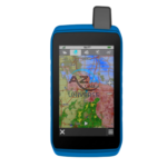
GPS SYSTEM AZA1039
AZA1039 GPS System (Professional GNSS Surveying Receiver)
The AZA1039 GPS System from Azalab is a high-performance, field-grade GNSS positioning solution engineered for land surveying, GIS mapping, construction layout, and geospatial data collection. Designed to deliver reliable accuracy in challenging environments, this system combines multi-constellation satellite tracking, real-time corrections, and rugged field durability.
Advanced Multi-Constellation GNSS Accuracy
Modern surveying demands precision beyond consumer-grade navigation devices. The AZA1039 utilizes multi-band GNSS technology, tracking multiple satellite constellations simultaneously, including:
-
GPS
-
GLONASS
-
Galileo
-
BeiDou
This ensures faster signal acquisition, higher positional reliability, and improved performance under tree canopy, near buildings, and in difficult terrain. When paired with RTK (Real-Time Kinematic) corrections, the system delivers centimeter-level accuracy, making it suitable for high-precision professional work.
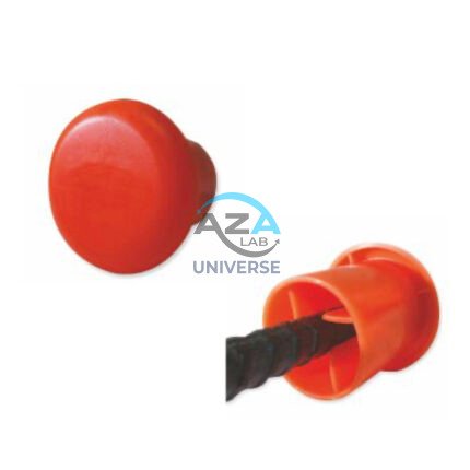
PROTECTIVE CAPS FOR REBAR, PIPE, BOLTS AZA1024
Multi-Purpose Safety Caps for Rebar, Pipes & Threaded Components by Azalab
AZA1024 Protective Caps are heavy-duty safety and maintenance accessories designed to protect workers, equipment, and materials on construction sites, industrial facilities, and fabrication yards. Engineered for injury prevention, corrosion protection, and regulatory compliance, these caps provide a simple yet highly effective solution for covering exposed rebars, pipe ends, bolts, and threaded rods.
Azalab’s AZA1024 range combines high visibility, impact resistance, and weather durability, making it suitable for demanding site conditions across residential, commercial, and infrastructure projects.

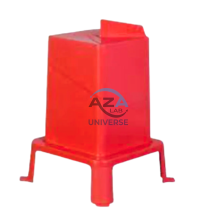
ROUND POST HOLE FORM AZA1020
Precision Cylindrical Concrete Formwork for Posts & Foundations by Azalab
The AZA1020 Round Post Hole Form is a high-performance cylindrical mold engineered for forming strong, uniform concrete footings for posts, poles, fences, and light structural foundations. Designed for both professional contractors and serious DIY users, this form ensures accuracy, speed, and consistency in concrete placement while minimizing material waste.
Ideal for fencing, decking, lighting poles, signposts, and temporary or permanent structures, the AZA1020 delivers clean finishes and dependable load-bearing performance.
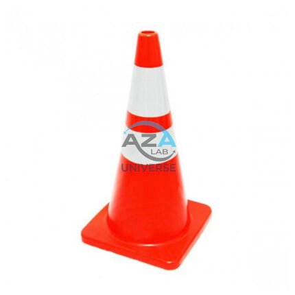
SAFETY CONE AZA1026
High-Visibility Traffic & Site Safety Cone by Azalab
The AZA1026 Safety Cone is a versatile and essential safety device used for traffic control, hazard marking, and area demarcation across construction sites, roads, laboratories, parking areas, and industrial facilities. Designed for maximum visibility, durability, and ease of handling, AZA1026 provides reliable performance in both indoor and outdoor environments.
SQUARE HOLE FORM AZA1021
Precision Square Concrete Footing Mold for Posts & Structural Bases by Azalab
The AZA1021 Square Hole Form is a rigid, pre-engineered concrete mold designed for forming accurate square foundations for posts, pillars, fencing systems, signage, decks, and structural columns. Engineered for speed, precision, and consistency, this form is ideal for residential, commercial, and infrastructure projects where square geometry and sharp edges are structurally or aesthetically required.
Available from Azalab, the AZA1021 enables contractors, landscapers, and builders to pour concrete footings cleanly and efficiently while reducing labor time and material waste.
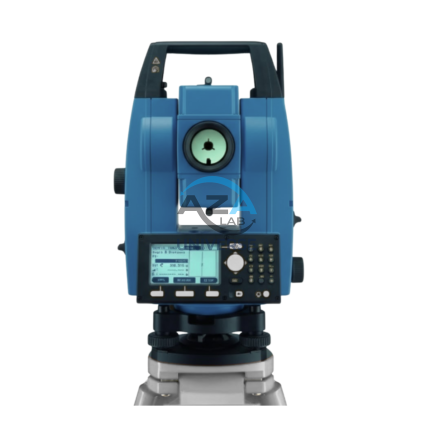
TOTAL STATION BUILDER AZA1029
AZA1029 Total Station Builder
The AZA1029 Total Station Builder is a high-precision digital surveying instrument engineered for construction layout, topographic surveying, and leveling applications. Combining an electronic theodolite, advanced EDM technology, and integrated survey software into a single rugged platform, AZA1029 delivers accuracy, efficiency, and reliability for demanding field environments.
Designed specifically for civil engineers, surveyors, and construction professionals, the AZA1029 ensures fast, repeatable, and highly accurate positioning across complex job sites.
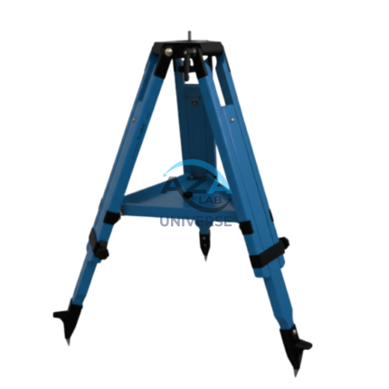
WOODEN TRIPOD AZA1038
Superior Stability with Natural Vibration Dampening
Unlike aluminum tripods, wooden tripods provide natural vibration absorption, making them the preferred choice for total stations, theodolites, laser scanners, and auto levels—especially for long-distance and high-accuracy measurements. The AZA1038 is manufactured from seasoned hardwood, carefully selected and treated to resist moisture, warping, and deformation, ensuring consistent performance in both dry and humid environments