 Rock
Rock Aggregate
 Cement
 Concrete
 Soil
Soil Steel
Steel Bitumen/Asphalt
 Security Survey Equipment
 General Items
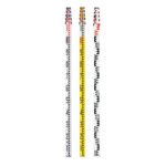
RANGE POLE AZA1035
The AZA1035 Range Pole is a precision surveying accessory designed to provide a stable and clearly visible vertical reference point for modern surveying, construction layout, and geospatial mapping applications. It is widely used with total stations, GPS/GNSS receivers, survey prisms, and alignment targets, ensuring accuracy and consistency in field measurements.
Reliable Vertical Reference for Surveying & GNSS
Range poles play a critical role in establishing line-of-sight alignment, boundary marking, control point positioning, and coordinate measurement. The AZA1035 ensures the mounted instrument or target remains vertically aligned, minimizing positional and height errors during data capture.
This makes it an essential tool for surveyors, civil engineers, and GIS professionals working in both urban and remote field conditions.
Description
Lightweight & Durable Construction
The AZA1035 is manufactured using high-strength aluminum or non-conductive fiberglass, offering an ideal balance of rigidity, durability, and portability. The pole resists bending, corrosion, and wear, making it suitable for prolonged outdoor use in harsh environments.
Fiberglass versions are particularly suited for work near electrical installations due to their non-conductive properties.
Telescopic & Height Adjustable Design
Featuring a telescopic multi-section design, the AZA1035 can be extended between 2 m and 5 m, depending on the selected model. Clear height graduations allow precise antenna or prism height setting, which is especially critical for GNSS RTK and total station workflows.
Secure twist-lock or flip-clamp mechanisms ensure the pole remains firmly locked at the selected height during operation.
Enhanced Stability & Vertical Accuracy
A hardened steel or stainless-steel pointed tip provides excellent ground penetration and stability on soil, asphalt, or compacted surfaces. An integrated circular bubble level near the head allows users to quickly verify vertical alignment, ensuring accurate positioning of GPS receivers or prisms.
High-Visibility for Long-Distance Targeting
The AZA1035 features high-contrast color patterns such as red–white, yellow–black, or red–yellow, making it easily visible from long distances through optical instruments. Select models include reflective markings to improve visibility in low-light or dusty conditions.
Wide Instrument Compatibility
The range pole is compatible with:
-
Total stations for angular and distance measurements
-
GPS / GNSS receivers for coordinate and elevation capture
-
Survey prisms for EDM applications
-
Alignment targets and markers for construction layout
Modular accessories such as prism mounts, GPS clamps, and target plates can be attached easily.
Typical Applications
The AZA1035 Range Pole is widely used in:
-
Land and topographic surveying
-
Boundary and control point marking
-
Road and infrastructure layout
-
GNSS RTK and GIS data collection
-
Construction alignment and staking
Technical Specifications – AZA1035
| Feature | Specification |
|---|---|
| Material | Aluminum / Fiberglass |
| Length Range | 2 m – 5 m (telescopic) |
| Sections | 2 to 5 (model-dependent) |
| Locking Mechanism | Twist lock / Flip clamp |
| Tip Type | Hardened steel / Stainless steel point |
| Color Options | Red–White / Yellow–Black / Red–Yellow |
| Graduation | Metric / Imperial (optional) |
| Level Bubble | Integrated circular bubble |
| Weight | Approx. 1.5 – 2.5 kg |
| Accessory Support | Prism mount, GPS clamp, target plate |
Key Features & Benefits
-
Used for GPS, total station, and alignment applications
-
Telescopic, lightweight aluminum or fiberglass construction
-
Adjustable height from 2 m to 5 m
-
High-visibility color patterns for long-distance sighting
-
Precision tip and integrated bubble level for accuracy
-
Compatible with prisms, GNSS receivers, and survey targets
-
Secure locking mechanism for stable positioning
-
Ideal for boundary marking and control point establishment
Frequently Asked Questions (FAQ)
Q1: What is the primary use of a range pole?
It provides a stable and visible vertical reference for GPS receivers, prisms, and alignment targets during surveying work.
Q2: Can a GNSS antenna or prism be mounted on AZA1035?
Yes. The pole supports standard survey accessories, including GNSS receivers and optical prisms.
Q3: Which material should I choose — aluminum or fiberglass?
Aluminum is lightweight and rigid; fiberglass is non-conductive and ideal near electrical installations.
Q4: Is it suitable for uneven or rough terrain?
Yes. The pointed steel tip and rigid body ensure stability on soft or uneven ground.
Q5: Does it include a bubble level?
Yes. An integrated circular bubble level ensures vertical alignment during measurements.
Additional information
| Material |
Aluminum / Fiberglass |
|---|---|
| Length Range |
2 m – 5 m (telescopic) |
| Sections |
2 to 5 (depending on model) |
| Locking Mechanism |
Twist Lock / Flip Clamp |
You may also like…

Related products

AUTOMATIC LEVEL AZA1031
AZA1031 Automatic Level (Auto Level / Optical Level)
The AZA1031 Automatic Level is a precision optical leveling instrument engineered for accurate elevation measurement in surveying, construction layout, and civil engineering projects. Designed for durability and long-term accuracy, it delivers consistent performance in demanding outdoor environments while remaining simple and efficient to operate.
Reliable Self-Leveling Performance
At the core of the AZA1031 is a magnetic damping compensator that automatically corrects minor tilts and vibrations. This self-leveling mechanism ensures a stable horizontal line of sight without continuous manual adjustment, significantly reducing setup time and operator error.
Once roughly leveled using the circular bubble vial, the internal compensator completes the leveling process automatically, making the instrument ideal for long-distance and repetitive leveling tasks.

AUTOMATIC LEVEL AZA1032
AZA1032 Automatic Level (Self-Leveling Optical Level)
The AZA1032 Automatic Level is a precision self-leveling optical instrument designed for accurate height transfer, alignment, and leveling operations in construction, surveying, and civil engineering projects. Engineered for reliability, ease of use, and field durability, it delivers consistent performance on demanding job sites.
Automatic Self-Leveling Accuracy
At the core of the AZA1032 is a built-in compensator mechanism that automatically aligns the line of sight to a true horizontal plane. After rough leveling using the circular bubble vial, the compensator fine-tunes alignment instantly, eliminating manual errors and significantly reducing setup time.
This self-leveling system ensures stable readings even in environments affected by vibration or minor ground movement.
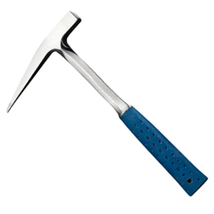
GEOLOGICAL HAMMER AZA1041
The Geological Hammer AZA1041 from Azalab is a robust, professional-grade field tool designed for rock sampling, mineral identification, fossil extraction, and geological exploration. It is an essential instrument for geologists, earth science students, archaeologists, mining professionals, and fossil enthusiasts, offering exceptional strength, balance, and reliability in demanding field conditions.
Engineered for rugged outdoor use, the hammer features a forged one-piece, heat-treated high-carbon steel head, ensuring superior impact resistance, long service life, and safety during repeated strikes. Unlike welded or cast alternatives, the forged construction prevents head separation and deformation, even when used on hard igneous or metamorphic rocks.
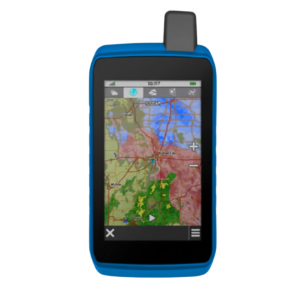
GPS SYSTEM AZA1039
AZA1039 GPS System (Professional GNSS Surveying Receiver)
The AZA1039 GPS System from Azalab is a high-performance, field-grade GNSS positioning solution engineered for land surveying, GIS mapping, construction layout, and geospatial data collection. Designed to deliver reliable accuracy in challenging environments, this system combines multi-constellation satellite tracking, real-time corrections, and rugged field durability.
Advanced Multi-Constellation GNSS Accuracy
Modern surveying demands precision beyond consumer-grade navigation devices. The AZA1039 utilizes multi-band GNSS technology, tracking multiple satellite constellations simultaneously, including:
-
GPS
-
GLONASS
-
Galileo
-
BeiDou
This ensures faster signal acquisition, higher positional reliability, and improved performance under tree canopy, near buildings, and in difficult terrain. When paired with RTK (Real-Time Kinematic) corrections, the system delivers centimeter-level accuracy, making it suitable for high-precision professional work.
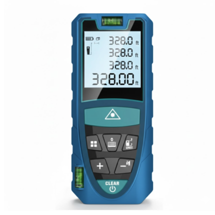
LASER DISTANCE METER AZA1030
AZA1030 Laser Distance Meter
The AZA1030 Laser Distance Meter is a compact, high-precision digital measuring instrument designed for fast, accurate, and efficient distance measurement across construction, interior design, surveying, and real estate applications. Replacing conventional tape measures, the AZA1030 delivers instant results at the push of a button while significantly reducing manual errors and site time.
Fast & Accurate Digital Measurement
Powered by advanced laser diode technology, the AZA1030 provides measurement accuracy up to ±1.5 mm, with model-dependent measuring ranges extending up to 100 meters. It supports multiple measuring functions, enabling professionals to capture complex dimensions quickly and reliably.
Measurement capabilities include:
-
Single and continuous distance measurement
-
Area and volume calculation
-
Indirect height and distance measurement (Pythagorean mode)
-
Minimum / maximum tracking
This makes AZA1030 ideal for layout planning, verification, and space assessment.

SAFETY HELMET AZA1025
Industrial & Laboratory Head Protection Helmet by Azalab
The AZA1025 Safety Helmet is a critical component of personal protective equipment (PPE), engineered to deliver reliable head protection, long-wearing comfort, and certified safety compliance across construction, industrial, laboratory, and infrastructure environments.
Designed using advanced materials and ergonomic principles, AZA1025 ensures maximum protection against falling objects, accidental impacts, and workplace hazards while remaining lightweight and comfortable for extended use.
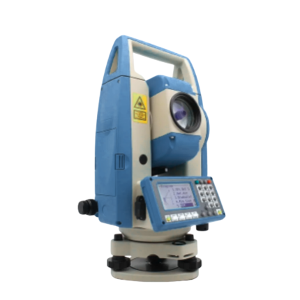
TOTAL STATION AZA1028
AZA1028 Total Station
The AZA1028 Total Station is a high-performance, all-in-one surveying instrument that integrates an electronic theodolite, electronic distance measurement (EDM), and advanced data recording into a single, robust platform. Designed for precision, efficiency, and durability, AZA1028 is an indispensable solution for civil engineers, construction professionals, land surveyors, and GIS specialists.
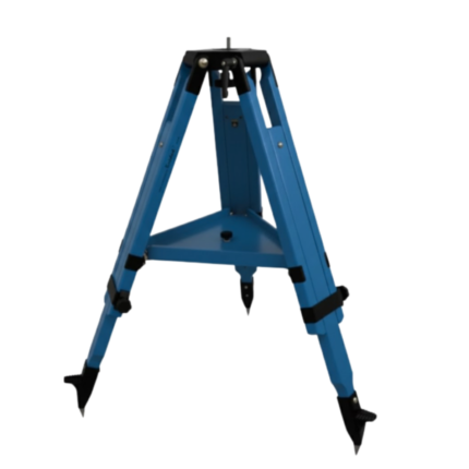
WOODEN TRIPOD AZA1038
Superior Stability with Natural Vibration Dampening
Unlike aluminum tripods, wooden tripods provide natural vibration absorption, making them the preferred choice for total stations, theodolites, laser scanners, and auto levels—especially for long-distance and high-accuracy measurements. The AZA1038 is manufactured from seasoned hardwood, carefully selected and treated to resist moisture, warping, and deformation, ensuring consistent performance in both dry and humid environments