
 Rock
Rock Aggregate
 Cement
 Concrete
 Soil
Soil Steel
Steel Bitumen/Asphalt
 Security Survey Equipment
 General Items
")
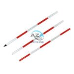
PRISM WITH POLE AZA1036
The AZA1036 Prism with Pole is a professional-grade surveying accessory designed for precise distance and angular measurements when used with total stations. This complete reflector-based surveying solution includes a high-accuracy prism, durable holder with target plate, and an adjustable telescopic pole—ensuring consistent performance across construction, cadastral, and topographic applications.
High-Precision Reflector for EDM Measurements
At the core of the AZA1036 is a single retroreflective survey prism, manufactured from high-purity optical glass and silver-coated for maximum signal return. The prism efficiently reflects the EDM signal back to the total station, enabling accurate distance measurement over long ranges—up to 2,000 meters, depending on instrument capability and site conditions.
The prism is housed in a rugged protective casing and mounted on a high-visibility target plate, allowing easy acquisition through the telescope even in low-light, foggy, or dusty environments.
Description
Standard Offset & Universal Compatibility
The AZA1036 prism supports standard offset values (-30 mm or 0 mm), making it fully compatible with leading total station brands including Leica, Topcon, Sokkia, Trimble, and Pentax. An integrated azimuth alignment ring ensures correct prism orientation regardless of the observation angle, reducing measurement errors during stakeout and control point surveys.
Adjustable Telescopic Prism Pole
The included telescopic prism pole is constructed from lightweight yet durable aluminum or fiberglass, offering excellent rigidity and portability. The pole extends from 1.5 m up to 5 m, with clearly marked metric or imperial graduations to allow precise height setting—critical for stakeout, elevation transfer, and offset measurements.
Secure twist-lock or flip-clamp mechanisms prevent height slippage during operation, ensuring measurement consistency.
Vertical Accuracy & Field Stability
To maintain perfect vertical alignment, the pole is equipped with an integrated circular bubble level, allowing the operator to keep the prism plumb during observations. This significantly minimizes vertical error, especially during long-range shots and high-accuracy control surveys.
The hardened base and robust pole construction provide stability on soil, asphalt, and compacted surfaces.
Rugged & Field-Ready Design
Designed for demanding site conditions, the AZA1036 prism assembly is sealed against dust and moisture, ensuring long service life and reliable performance in outdoor environments. The complete set is lightweight, easy to transport, and supplied with a protective carrying case for safe storage and mobility.
The modular design allows the prism to be easily removed or repositioned on the pole, offering flexibility for backsight, foresight, boundary marking, and elevation verification tasks.
Typical Applications
The AZA1036 Prism with Pole is ideal for:
-
Site layout and stakeout surveys
-
Control point and benchmark measurement
-
Boundary demarcation and cadastral surveys
-
Angle and distance triangulation
-
Road, rail, and infrastructure projects
-
Topographic and as-built surveys
Technical Specifications – AZA1036
| Feature | Specification |
|---|---|
| Prism Type | Single retroreflective, silver-coated |
| Prism Offset | -30 mm / 0 mm (selectable) |
| Reflective Range | Up to 2,000 m |
| Pole Material | Aluminum / Fiberglass |
| Pole Height Range | 1.5 m – 5 m (telescopic) |
| Pole Graduation | Metric / Imperial |
| Target Plate | Included, high-visibility |
| Bubble Level | Integrated circular level |
| Lock Type | Twist-lock / Flip clamp |
| Compatibility | Leica, Topcon, Sokkia, Trimble, Pentax |
| Carrying Case | Included (soft or hard shell) |
Key Features & Benefits
-
Complete prism and pole assembly for total station use
-
High-accuracy silver-coated survey prism
-
Long-range EDM capability up to 2,000 m
-
Telescopic pole with precise height graduations
-
Integrated bubble level for vertical alignment
-
Adjustable prism offset for universal compatibility
-
Durable, weather-resistant construction
-
Ideal for stakeout, layout, and control surveys
Frequently Asked Questions (FAQ)
Q1: What is the primary function of a survey prism?
It reflects the EDM signal from a total station, enabling accurate distance and angle measurement.
Q2: Is the AZA1036 compatible with all total stations?
Yes. It supports standard prism offsets and works with most major total station brands.
Q3: How tall does the prism pole extend?
The telescopic pole extends from 1.5 m to 5 m with clear graduations.
Q4: Does the set include a bubble level?
Yes. A built-in circular bubble level ensures proper vertical alignment.
Q5: Is it suitable for stakeout and boundary work?
Absolutely. It is designed specifically for stakeout, layout, and boundary demarcation tasks.
Additional information
| Prism Type |
Single retroreflective, silver-coated |
|---|---|
| Prism Offset |
-30 mm / 0 mm (selectable) |
| Reflective Range |
Up to 2,000 meters |
| Pole Material |
Aluminum / Fiberglass |
You may also like…
Related products
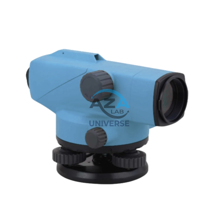
AUTOMATIC LEVEL AZA1031
AZA1031 Automatic Level (Auto Level / Optical Level)
The AZA1031 Automatic Level is a precision optical leveling instrument engineered for accurate elevation measurement in surveying, construction layout, and civil engineering projects. Designed for durability and long-term accuracy, it delivers consistent performance in demanding outdoor environments while remaining simple and efficient to operate.
Reliable Self-Leveling Performance
At the core of the AZA1031 is a magnetic damping compensator that automatically corrects minor tilts and vibrations. This self-leveling mechanism ensures a stable horizontal line of sight without continuous manual adjustment, significantly reducing setup time and operator error.
Once roughly leveled using the circular bubble vial, the internal compensator completes the leveling process automatically, making the instrument ideal for long-distance and repetitive leveling tasks.
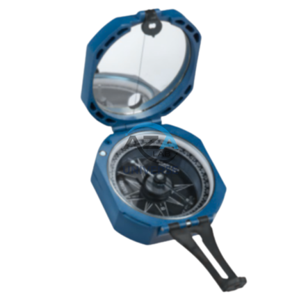
BRUNTON COMPASS AZA1042
The Brunton Compass AZA1042 from Azalab is a professional-grade field instrument engineered for high-precision geological mapping, structural analysis, environmental surveying, and navigation. Recognized globally as the industry benchmark, this compass is trusted by geologists, civil engineers, surveyors, archaeologists, researchers, and students working in demanding outdoor environments.
Unlike conventional handheld compasses, the Brunton Compass is a multi-functional surveying tool, integrating a magnetic compass, clinometer, protractor, and mirror sighting system into a single compact instrument. This versatility allows accurate measurement of azimuth, strike, dip, inclination, and slope angles, making it indispensable for scientific fieldwork.
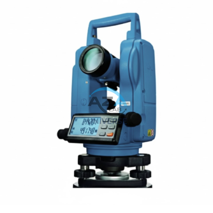
ELECTRONIC THEODOLITE AZA1027
Precision Redefined for Field Surveying
The AZA1027 is an essential instrument for topographic surveys, construction layout, and structural alignment. Equipped with high-resolution angle encoders, it significantly reduces reading errors and ensures consistent measurement accuracy.
An integrated optical plummet and dual-axis compensator allow reliable operation even on uneven terrain. With angular accuracy ranging from ±2″ to ±5″ seconds (model dependent), the AZA1027 is ideal for projects requiring tight tolerances such as bridges, tunnels, and high-rise structures.
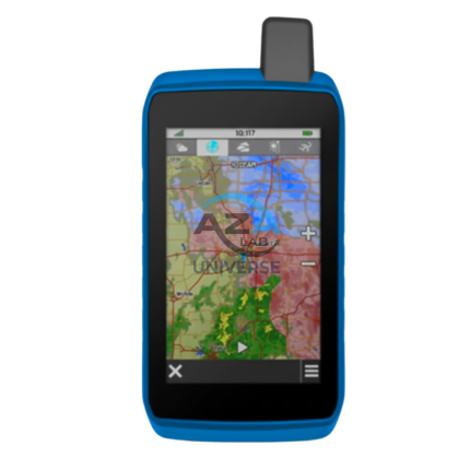
GPS SYSTEM AZA1039
AZA1039 GPS System (Professional GNSS Surveying Receiver)
The AZA1039 GPS System from Azalab is a high-performance, field-grade GNSS positioning solution engineered for land surveying, GIS mapping, construction layout, and geospatial data collection. Designed to deliver reliable accuracy in challenging environments, this system combines multi-constellation satellite tracking, real-time corrections, and rugged field durability.
Advanced Multi-Constellation GNSS Accuracy
Modern surveying demands precision beyond consumer-grade navigation devices. The AZA1039 utilizes multi-band GNSS technology, tracking multiple satellite constellations simultaneously, including:
-
GPS
-
GLONASS
-
Galileo
-
BeiDou
This ensures faster signal acquisition, higher positional reliability, and improved performance under tree canopy, near buildings, and in difficult terrain. When paired with RTK (Real-Time Kinematic) corrections, the system delivers centimeter-level accuracy, making it suitable for high-precision professional work.
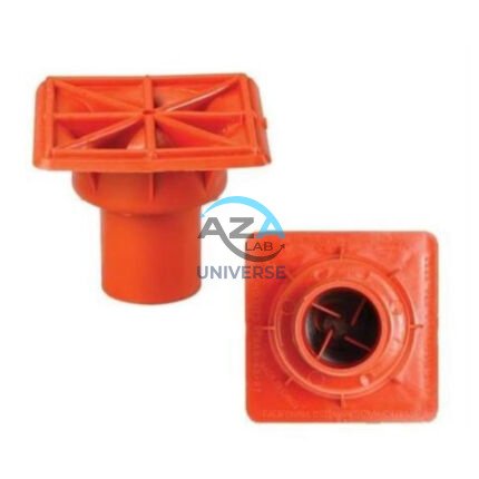
IMPALEMENT SAFETY COVERS AZA1023
Rebar Protection Solutions for Construction Site Safety & Compliance by Azalab
AZA1023 Impalement Safety Covers are critical safety components designed to protect workers, visitors, and pedestrians from impalement hazards caused by exposed reinforcement bars (rebars) on construction sites. These covers significantly reduce the risk of serious injury or fatal accidents while helping projects comply with mandatory safety regulations such as OSHA, BIS, and international construction safety standards.
At Azalab, safety is engineered into every detail. The AZA1023 range is developed to deliver high impact resistance, excellent visibility, easy installation, and long service life, making it an essential safety accessory for residential, commercial, and large-scale infrastructure projects
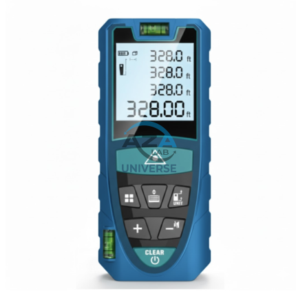
LASER DISTANCE METER AZA1030
AZA1030 Laser Distance Meter
The AZA1030 Laser Distance Meter is a compact, high-precision digital measuring instrument designed for fast, accurate, and efficient distance measurement across construction, interior design, surveying, and real estate applications. Replacing conventional tape measures, the AZA1030 delivers instant results at the push of a button while significantly reducing manual errors and site time.
Fast & Accurate Digital Measurement
Powered by advanced laser diode technology, the AZA1030 provides measurement accuracy up to ±1.5 mm, with model-dependent measuring ranges extending up to 100 meters. It supports multiple measuring functions, enabling professionals to capture complex dimensions quickly and reliably.
Measurement capabilities include:
-
Single and continuous distance measurement
-
Area and volume calculation
-
Indirect height and distance measurement (Pythagorean mode)
-
Minimum / maximum tracking
This makes AZA1030 ideal for layout planning, verification, and space assessment.
SQUARE HOLE FORM AZA1021
Precision Square Concrete Footing Mold for Posts & Structural Bases by Azalab
The AZA1021 Square Hole Form is a rigid, pre-engineered concrete mold designed for forming accurate square foundations for posts, pillars, fencing systems, signage, decks, and structural columns. Engineered for speed, precision, and consistency, this form is ideal for residential, commercial, and infrastructure projects where square geometry and sharp edges are structurally or aesthetically required.
Available from Azalab, the AZA1021 enables contractors, landscapers, and builders to pour concrete footings cleanly and efficiently while reducing labor time and material waste.
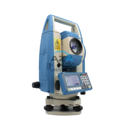
TOTAL STATION AZA1028
AZA1028 Total Station
The AZA1028 Total Station is a high-performance, all-in-one surveying instrument that integrates an electronic theodolite, electronic distance measurement (EDM), and advanced data recording into a single, robust platform. Designed for precision, efficiency, and durability, AZA1028 is an indispensable solution for civil engineers, construction professionals, land surveyors, and GIS specialists.