
 Rock
Rock Aggregate
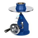 Cement
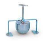 Concrete
 Soil
Soil Steel
Steel Bitumen/Asphalt
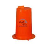 Security Survey Equipment
 General Items
")
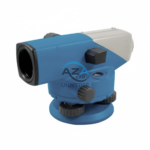
AUTOMATIC LEVEL AZA1031
AZA1031 Automatic Level (Auto Level / Optical Level)
The AZA1031 Automatic Level is a precision optical leveling instrument engineered for accurate elevation measurement in surveying, construction layout, and civil engineering projects. Designed for durability and long-term accuracy, it delivers consistent performance in demanding outdoor environments while remaining simple and efficient to operate.
Reliable Self-Leveling Performance
At the core of the AZA1031 is a magnetic damping compensator that automatically corrects minor tilts and vibrations. This self-leveling mechanism ensures a stable horizontal line of sight without continuous manual adjustment, significantly reducing setup time and operator error.
Once roughly leveled using the circular bubble vial, the internal compensator completes the leveling process automatically, making the instrument ideal for long-distance and repetitive leveling tasks.
Description
Clear Optics & High Accuracy
The AZA1031 features high-quality optical lenses with magnification options ranging from 24x to 32x (model-dependent). This provides a sharp, bright image of the leveling staff even at distances exceeding 100 meters.
With an accuracy of ±2.0 to ±2.5 mm per kilometer of double-run leveling, the instrument is well-suited for:
-
Road and highway construction
-
Building foundation and floor leveling
-
Pipeline and drainage gradient control
-
Land surveying and boundary work
The large objective aperture enhances light gathering, ensuring confident staff readings under varying site conditions.
360° Horizontal Measurement Capability
The AZA1031 is equipped with a 360-degree graduated horizontal circle, allowing users to perform basic horizontal angle measurements and alignments. Smooth rotation, fine-motion adjustment, and locking knobs enable precise targeting during layout and benchmarking operations.
Rugged, Site-Ready Construction
Built for harsh field conditions, the AZA1031 is housed in a shock-resistant and water-resistant casing. The IP-rated design protects internal optics and mechanical components from dust, moisture, and vibration, ensuring reliable operation in wet, dusty, or uneven environments.
The instrument mounts securely on a standard 5/8-inch tripod thread, making it compatible with all common surveying tripods and leveling staffs (metric or imperial).
Simple Setup & Long-Term Reliability
Setup is fast and straightforward:
-
Mount on tripod
-
Roughly level using the bubble vial
-
Let the automatic compensator finalize leveling
Each unit is factory-calibrated and supplied with essential accessories. On-site recalibration is possible using built-in adjustment screws, ensuring long service life even after transport or extended use.
Typical Applications
The AZA1031 Automatic Level is widely used in:
-
Roadwork and highway projects
-
Building foundations and slab leveling
-
Drainage, canal, and pipeline gradients
-
Bridge and culvert construction
-
Civil engineering education and training labs
Its intuitive operation makes it suitable for both experienced professionals and students.
Technical Specifications – AZA1031
| Feature | Specification |
|---|---|
| Telescope Magnification | 24x / 28x / 32x (model-dependent) |
| Objective Aperture | 36 mm |
| Minimum Focus Distance | 0.3 – 0.5 m |
| Accuracy | ±2.0 to ±2.5 mm per 1 km double-run |
| Compensator Type | Magnetic damping |
| Compensator Range | ±15 arc minutes |
| Horizontal Circle | 360° graduated |
| Dust & Water Protection | IP54 / IP65 (model-dependent) |
| Tripod Mount | Standard 5/8-inch thread |
| Weight | Approx. 1.5 – 2.5 kg |
| Supplied Accessories | Carrying case, adjustment tools, lens cloth, manual |
Key Advantages of AZA1031
-
Automatic leveling via magnetic damping compensator
-
24x–32x magnification for long-range visibility
-
High accuracy: ±2.5 mm over 1 km double-run leveling
-
Rugged, waterproof, and dust-resistant construction
-
Smooth horizontal angle measurement with 360° scale
-
Compatible with standard tripods and leveling staffs
-
Supplied with protective case and adjustment tools
Frequently Asked Questions (FAQ)
Q1: Is the AZA1031 suitable for beginners?
Yes. The automatic compensator makes operation simple and user-friendly.
Q2: What accuracy does it provide for construction work?
It delivers ±2.5 mm or better per kilometer, suitable for most civil and layout applications.
Q3: Can it be used in rain or dusty environments?
Yes. The IP-rated housing protects against dust and moisture.
Q4: Does it require frequent calibration?
Only periodic calibration is recommended, especially after transport or impact.
Q5: What accessories are required for use?
A tripod and leveling staff are required. The instrument is supplied with a case, tools, and manual.
Additional information
| Telescope Magnification |
24x / 28x / 32x (model-dependent) |
|---|---|
| Objective Aperture |
36 mm |
| Minimum Focus Distance |
0.3 – 0.5 m |
| Accuracy |
±2.0 to ±2.5 mm per 1 km double-run leveling |
Related products
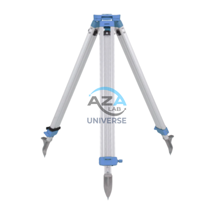
ALUMINUM TRIPOD AZA1037
AZA1037 Aluminum Tripod (Surveying & Construction Instrument Stand)
The AZA1037 Aluminum Tripod from Azalab is a high-precision, field-ready instrument stand engineered to provide maximum stability, portability, and durability for professional surveying and construction applications. It serves as a reliable mounting platform for auto levels, total stations, theodolites, rotary lasers, and mapping instruments, ensuring accurate measurements in demanding site conditions.
Lightweight & Corrosion-Resistant Construction
Manufactured from high-grade anodized aluminum alloy, the AZA1037 tripod offers an optimal balance between strength and weight. The corrosion-resistant finish makes it suitable for prolonged outdoor use, including dusty construction sites, uneven terrain, and damp environments, without compromising structural integrity or performance.
Despite its robust construction, the tripod remains lightweight, allowing easy handling and transportation between job locations.
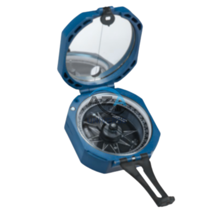
BRUNTON COMPASS AZA1042
The Brunton Compass AZA1042 from Azalab is a professional-grade field instrument engineered for high-precision geological mapping, structural analysis, environmental surveying, and navigation. Recognized globally as the industry benchmark, this compass is trusted by geologists, civil engineers, surveyors, archaeologists, researchers, and students working in demanding outdoor environments.
Unlike conventional handheld compasses, the Brunton Compass is a multi-functional surveying tool, integrating a magnetic compass, clinometer, protractor, and mirror sighting system into a single compact instrument. This versatility allows accurate measurement of azimuth, strike, dip, inclination, and slope angles, making it indispensable for scientific fieldwork.
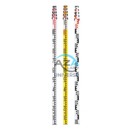
LEVELLING STAVES AZA1034
AZA1034 Levelling Staves (Survey Staff / Leveling Staff)
The AZA1034 Levelling Staff is an essential surveying accessory used in conjunction with dumpy levels, automatic levels, and digital levels to accurately measure height differences between ground points. Designed for reliability, visibility, and ease of handling, it is a critical tool for construction, civil engineering, and land surveying applications.
Accurate Elevation Measurement
Levelling staves provide a vertical reference that allows surveyors and engineers to determine elevation differences with precision. When viewed through an optical leveling instrument, the graduated scale on the AZA1034 enables clear and accurate readings, ensuring dependable height transfer across distances.
The staff is available with metric (cm/m) or imperial (ft/in) graduations, depending on project requirements.
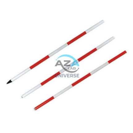
RANGE POLE AZA1035
Reliable Vertical Reference for Surveying & GNSS
Range poles play a critical role in establishing line-of-sight alignment, boundary marking, control point positioning, and coordinate measurement. The AZA1035 ensures the mounted instrument or target remains vertically aligned, minimizing positional and height errors during data capture. This makes it an essential tool for surveyors, civil engineers, and GIS professionals working in both urban and remote field conditions.
ROUND POST HOLE FORM AZA1020
Precision Cylindrical Concrete Formwork for Posts & Foundations by Azalab
The AZA1020 Round Post Hole Form is a high-performance cylindrical mold engineered for forming strong, uniform concrete footings for posts, poles, fences, and light structural foundations. Designed for both professional contractors and serious DIY users, this form ensures accuracy, speed, and consistency in concrete placement while minimizing material waste.
Ideal for fencing, decking, lighting poles, signposts, and temporary or permanent structures, the AZA1020 delivers clean finishes and dependable load-bearing performance.
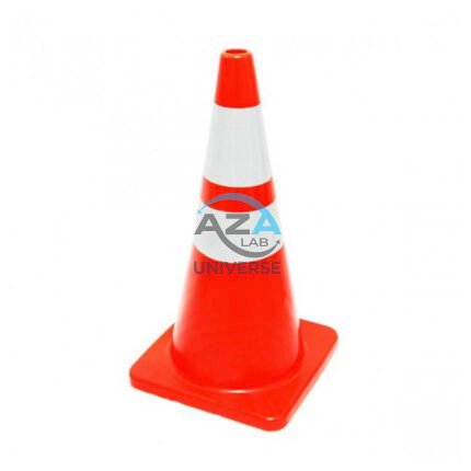
SAFETY CONE AZA1026
High-Visibility Traffic & Site Safety Cone by Azalab
The AZA1026 Safety Cone is a versatile and essential safety device used for traffic control, hazard marking, and area demarcation across construction sites, roads, laboratories, parking areas, and industrial facilities. Designed for maximum visibility, durability, and ease of handling, AZA1026 provides reliable performance in both indoor and outdoor environments.
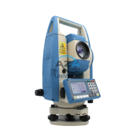
TOTAL STATION AZA1028
AZA1028 Total Station
The AZA1028 Total Station is a high-performance, all-in-one surveying instrument that integrates an electronic theodolite, electronic distance measurement (EDM), and advanced data recording into a single, robust platform. Designed for precision, efficiency, and durability, AZA1028 is an indispensable solution for civil engineers, construction professionals, land surveyors, and GIS specialists.
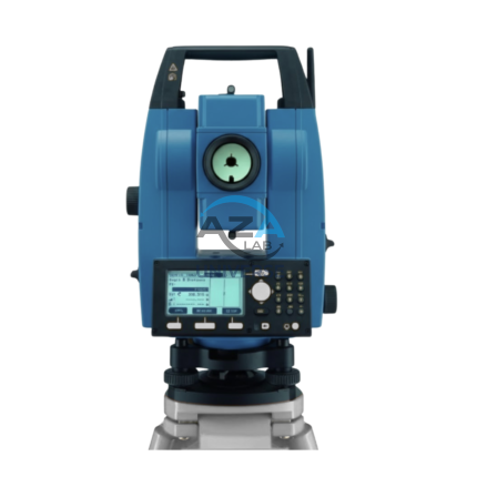
TOTAL STATION BUILDER AZA1029
AZA1029 Total Station Builder
The AZA1029 Total Station Builder is a high-precision digital surveying instrument engineered for construction layout, topographic surveying, and leveling applications. Combining an electronic theodolite, advanced EDM technology, and integrated survey software into a single rugged platform, AZA1029 delivers accuracy, efficiency, and reliability for demanding field environments.
Designed specifically for civil engineers, surveyors, and construction professionals, the AZA1029 ensures fast, repeatable, and highly accurate positioning across complex job sites.