
 Rock
Rock Aggregate
 Cement
 Concrete
 Soil
Soil Steel
Steel Bitumen/Asphalt
 Security Survey Equipment
 General Items
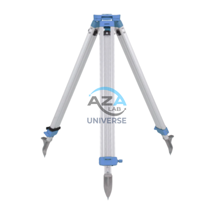
ALUMINUM TRIPOD AZA1037
AZA1037 Aluminum Tripod (Surveying & Construction Instrument Stand)
The AZA1037 Aluminum Tripod from Azalab is a high-precision, field-ready instrument stand engineered to provide maximum stability, portability, and durability for professional surveying and construction applications. It serves as a reliable mounting platform for auto levels, total stations, theodolites, rotary lasers, and mapping instruments, ensuring accurate measurements in demanding site conditions.
Lightweight & Corrosion-Resistant Construction
Manufactured from high-grade anodized aluminum alloy, the AZA1037 tripod offers an optimal balance between strength and weight. The corrosion-resistant finish makes it suitable for prolonged outdoor use, including dusty construction sites, uneven terrain, and damp environments, without compromising structural integrity or performance.
Despite its robust construction, the tripod remains lightweight, allowing easy handling and transportation between job locations.
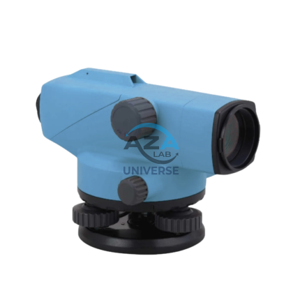
AUTOMATIC LEVEL AZA1031
AZA1031 Automatic Level (Auto Level / Optical Level)
The AZA1031 Automatic Level is a precision optical leveling instrument engineered for accurate elevation measurement in surveying, construction layout, and civil engineering projects. Designed for durability and long-term accuracy, it delivers consistent performance in demanding outdoor environments while remaining simple and efficient to operate.
Reliable Self-Leveling Performance
At the core of the AZA1031 is a magnetic damping compensator that automatically corrects minor tilts and vibrations. This self-leveling mechanism ensures a stable horizontal line of sight without continuous manual adjustment, significantly reducing setup time and operator error.
Once roughly leveled using the circular bubble vial, the internal compensator completes the leveling process automatically, making the instrument ideal for long-distance and repetitive leveling tasks.
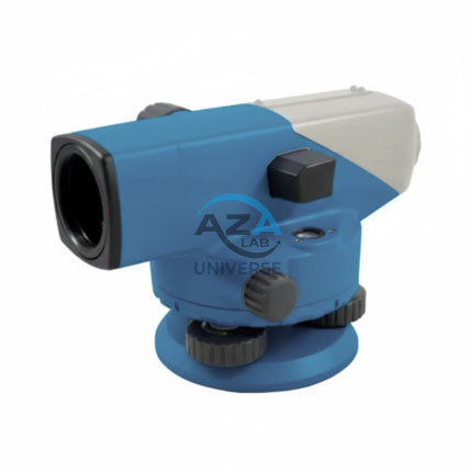
AUTOMATIC LEVEL AZA1032
AZA1032 Automatic Level (Self-Leveling Optical Level)
The AZA1032 Automatic Level is a precision self-leveling optical instrument designed for accurate height transfer, alignment, and leveling operations in construction, surveying, and civil engineering projects. Engineered for reliability, ease of use, and field durability, it delivers consistent performance on demanding job sites.
Automatic Self-Leveling Accuracy
At the core of the AZA1032 is a built-in compensator mechanism that automatically aligns the line of sight to a true horizontal plane. After rough leveling using the circular bubble vial, the compensator fine-tunes alignment instantly, eliminating manual errors and significantly reducing setup time.
This self-leveling system ensures stable readings even in environments affected by vibration or minor ground movement.
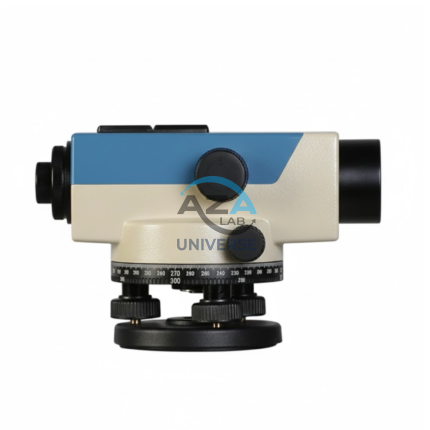
AUTOMATIC LEVEL AZA1033
AZA1033 Automatic Level (Auto Level / Self-Leveling Optical Level)
The AZA1033 Automatic Level is a high-precision optical surveying instrument engineered for accurate elevation measurement in construction, roadwork, and civil engineering projects. Designed to establish and verify horizontal planes over long distances, it is an essential tool for engineers, surveyors, and site supervisors who require speed, stability, and dependable accuracy.
Self-Leveling Accuracy with Built-in Compensator
Unlike manual leveling instruments, the AZA1033 features a self-leveling compensator system that automatically maintains a true horizontal line of sight. Once roughly leveled using the circular bubble vial, the internal compensator corrects minor tilts and vibrations instantly.
This mechanism significantly reduces setup time, eliminates operator error, and ensures stable readings even on uneven ground or vibration-prone sites
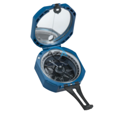
BRUNTON COMPASS AZA1042
The Brunton Compass AZA1042 from Azalab is a professional-grade field instrument engineered for high-precision geological mapping, structural analysis, environmental surveying, and navigation. Recognized globally as the industry benchmark, this compass is trusted by geologists, civil engineers, surveyors, archaeologists, researchers, and students working in demanding outdoor environments.
Unlike conventional handheld compasses, the Brunton Compass is a multi-functional surveying tool, integrating a magnetic compass, clinometer, protractor, and mirror sighting system into a single compact instrument. This versatility allows accurate measurement of azimuth, strike, dip, inclination, and slope angles, making it indispensable for scientific fieldwork.
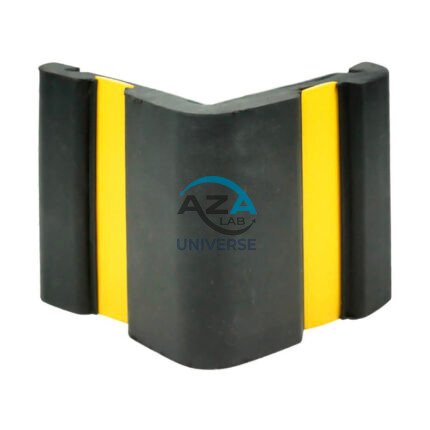
CORNER GUARD AZA1022
Wall & Edge Protection Solutions for Safety, Durability, and Aesthetics by Azalab
The AZA1022 Corner Guards are a practical, durable, and cost-effective solution for protecting wall edges and exposed corners from impact damage in both residential and commercial environments. Designed to prevent chipping, cracking, abrasion, and collision damage, these guards are especially essential in high-traffic areas where trolleys, carts, wheelchairs, forklifts, or vehicles are frequently in use.
Azalab’s AZA1022 range combines impact resistance, safety visibility, and clean aesthetics, ensuring long-term protection while maintaining the visual integrity of interior and exterior spaces.
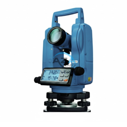
ELECTRONIC THEODOLITE AZA1027
Precision Redefined for Field Surveying
The AZA1027 is an essential instrument for topographic surveys, construction layout, and structural alignment. Equipped with high-resolution angle encoders, it significantly reduces reading errors and ensures consistent measurement accuracy.
An integrated optical plummet and dual-axis compensator allow reliable operation even on uneven terrain. With angular accuracy ranging from ±2″ to ±5″ seconds (model dependent), the AZA1027 is ideal for projects requiring tight tolerances such as bridges, tunnels, and high-rise structures.
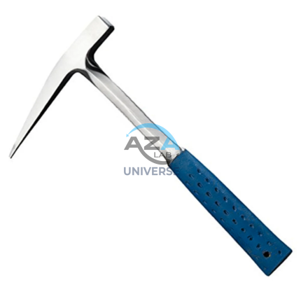
GEOLOGICAL HAMMER AZA1041
The Geological Hammer AZA1041 from Azalab is a robust, professional-grade field tool designed for rock sampling, mineral identification, fossil extraction, and geological exploration. It is an essential instrument for geologists, earth science students, archaeologists, mining professionals, and fossil enthusiasts, offering exceptional strength, balance, and reliability in demanding field conditions.
Engineered for rugged outdoor use, the hammer features a forged one-piece, heat-treated high-carbon steel head, ensuring superior impact resistance, long service life, and safety during repeated strikes. Unlike welded or cast alternatives, the forged construction prevents head separation and deformation, even when used on hard igneous or metamorphic rocks.
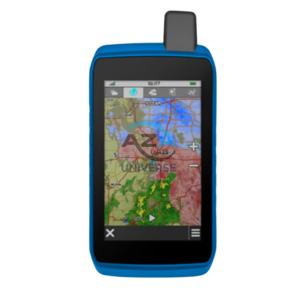
GPS SYSTEM AZA1039
AZA1039 GPS System (Professional GNSS Surveying Receiver)
The AZA1039 GPS System from Azalab is a high-performance, field-grade GNSS positioning solution engineered for land surveying, GIS mapping, construction layout, and geospatial data collection. Designed to deliver reliable accuracy in challenging environments, this system combines multi-constellation satellite tracking, real-time corrections, and rugged field durability.
Advanced Multi-Constellation GNSS Accuracy
Modern surveying demands precision beyond consumer-grade navigation devices. The AZA1039 utilizes multi-band GNSS technology, tracking multiple satellite constellations simultaneously, including:
-
GPS
-
GLONASS
-
Galileo
-
BeiDou
This ensures faster signal acquisition, higher positional reliability, and improved performance under tree canopy, near buildings, and in difficult terrain. When paired with RTK (Real-Time Kinematic) corrections, the system delivers centimeter-level accuracy, making it suitable for high-precision professional work.
Designed for Professional Surveying & GIS Applications
The AZA1039 is purpose-built for:
-
Land and boundary surveys
-
Topographic and contour mapping
-
GIS data acquisition
-
Construction staking and alignment
-
Agriculture and environmental monitoring
-
Mining and infrastructure planning
Surveyors, civil engineers, GIS analysts, and planning professionals rely on the AZA1039 for confident, location-based decision-making.
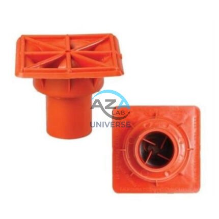
IMPALEMENT SAFETY COVERS AZA1023
Rebar Protection Solutions for Construction Site Safety & Compliance by Azalab
AZA1023 Impalement Safety Covers are critical safety components designed to protect workers, visitors, and pedestrians from impalement hazards caused by exposed reinforcement bars (rebars) on construction sites. These covers significantly reduce the risk of serious injury or fatal accidents while helping projects comply with mandatory safety regulations such as OSHA, BIS, and international construction safety standards.
At Azalab, safety is engineered into every detail. The AZA1023 range is developed to deliver high impact resistance, excellent visibility, easy installation, and long service life, making it an essential safety accessory for residential, commercial, and large-scale infrastructure projects
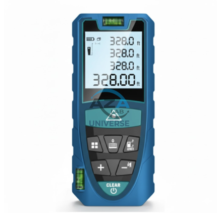
LASER DISTANCE METER AZA1030
AZA1030 Laser Distance Meter
The AZA1030 Laser Distance Meter is a compact, high-precision digital measuring instrument designed for fast, accurate, and efficient distance measurement across construction, interior design, surveying, and real estate applications. Replacing conventional tape measures, the AZA1030 delivers instant results at the push of a button while significantly reducing manual errors and site time.
Fast & Accurate Digital Measurement
Powered by advanced laser diode technology, the AZA1030 provides measurement accuracy up to ±1.5 mm, with model-dependent measuring ranges extending up to 100 meters. It supports multiple measuring functions, enabling professionals to capture complex dimensions quickly and reliably.
Measurement capabilities include:
-
Single and continuous distance measurement
-
Area and volume calculation
-
Indirect height and distance measurement (Pythagorean mode)
-
Minimum / maximum tracking
This makes AZA1030 ideal for layout planning, verification, and space assessment.
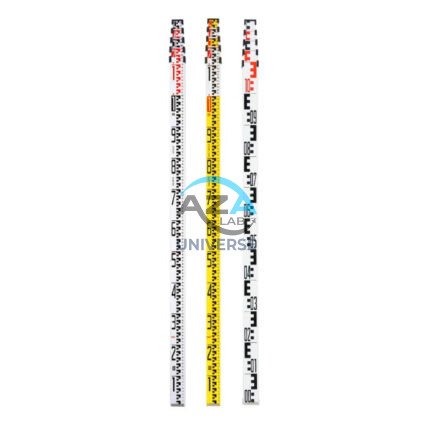
LEVELLING STAVES AZA1034
AZA1034 Levelling Staves (Survey Staff / Leveling Staff)
The AZA1034 Levelling Staff is an essential surveying accessory used in conjunction with dumpy levels, automatic levels, and digital levels to accurately measure height differences between ground points. Designed for reliability, visibility, and ease of handling, it is a critical tool for construction, civil engineering, and land surveying applications.
Accurate Elevation Measurement
Levelling staves provide a vertical reference that allows surveyors and engineers to determine elevation differences with precision. When viewed through an optical leveling instrument, the graduated scale on the AZA1034 enables clear and accurate readings, ensuring dependable height transfer across distances.
The staff is available with metric (cm/m) or imperial (ft/in) graduations, depending on project requirements.

 Rock
Rock Aggregate
 Cement
 Concrete
 Soil
Soil Steel
Steel Bitumen/Asphalt
 Security Survey Equipment
 General Items