
 Rock
Rock Aggregate
 Cement
 Concrete
 Soil
Soil Steel
Steel Bitumen/Asphalt
 Security Survey Equipment
 General Items

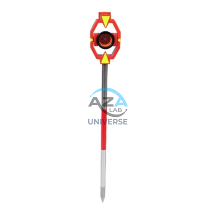
RANGE POLE AZA1035
The AZA1035 Range Pole is a precision surveying accessory designed to provide a stable and clearly visible vertical reference point for modern surveying, construction layout, and geospatial mapping applications. It is widely used with total stations, GPS/GNSS receivers, survey prisms, and alignment targets, ensuring accuracy and consistency in field measurements.
Reliable Vertical Reference for Surveying & GNSS
Range poles play a critical role in establishing line-of-sight alignment, boundary marking, control point positioning, and coordinate measurement. The AZA1035 ensures the mounted instrument or target remains vertically aligned, minimizing positional and height errors during data capture.
This makes it an essential tool for surveyors, civil engineers, and GIS professionals working in both urban and remote field conditions.
Description
Lightweight & Durable Construction
The AZA1035 is manufactured using high-strength aluminum or non-conductive fiberglass, offering an ideal balance of rigidity, durability, and portability. The pole resists bending, corrosion, and wear, making it suitable for prolonged outdoor use in harsh environments.
Fiberglass versions are particularly suited for work near electrical installations due to their non-conductive properties.
Telescopic & Height Adjustable Design
Featuring a telescopic multi-section design, the AZA1035 can be extended between 2 m and 5 m, depending on the selected model. Clear height graduations allow precise antenna or prism height setting, which is especially critical for GNSS RTK and total station workflows.
Secure twist-lock or flip-clamp mechanisms ensure the pole remains firmly locked at the selected height during operation.
Enhanced Stability & Vertical Accuracy
A hardened steel or stainless-steel pointed tip provides excellent ground penetration and stability on soil, asphalt, or compacted surfaces. An integrated circular bubble level near the head allows users to quickly verify vertical alignment, ensuring accurate positioning of GPS receivers or prisms.
High-Visibility for Long-Distance Targeting
The AZA1035 features high-contrast color patterns such as red–white, yellow–black, or red–yellow, making it easily visible from long distances through optical instruments. Select models include reflective markings to improve visibility in low-light or dusty conditions.
Wide Instrument Compatibility
The range pole is compatible with:
-
Total stations for angular and distance measurements
-
GPS / GNSS receivers for coordinate and elevation capture
-
Survey prisms for EDM applications
-
Alignment targets and markers for construction layout
Modular accessories such as prism mounts, GPS clamps, and target plates can be attached easily.
Typical Applications
The AZA1035 Range Pole is widely used in:
-
Land and topographic surveying
-
Boundary and control point marking
-
Road and infrastructure layout
-
GNSS RTK and GIS data collection
-
Construction alignment and staking
Technical Specifications – AZA1035
| Feature | Specification |
|---|---|
| Material | Aluminum / Fiberglass |
| Length Range | 2 m – 5 m (telescopic) |
| Sections | 2 to 5 (model-dependent) |
| Locking Mechanism | Twist lock / Flip clamp |
| Tip Type | Hardened steel / Stainless steel point |
| Color Options | Red–White / Yellow–Black / Red–Yellow |
| Graduation | Metric / Imperial (optional) |
| Level Bubble | Integrated circular bubble |
| Weight | Approx. 1.5 – 2.5 kg |
| Accessory Support | Prism mount, GPS clamp, target plate |
Key Features & Benefits
-
Used for GPS, total station, and alignment applications
-
Telescopic, lightweight aluminum or fiberglass construction
-
Adjustable height from 2 m to 5 m
-
High-visibility color patterns for long-distance sighting
-
Precision tip and integrated bubble level for accuracy
-
Compatible with prisms, GNSS receivers, and survey targets
-
Secure locking mechanism for stable positioning
-
Ideal for boundary marking and control point establishment
Frequently Asked Questions (FAQ)
Q1: What is the primary use of a range pole?
It provides a stable and visible vertical reference for GPS receivers, prisms, and alignment targets during surveying work.
Q2: Can a GNSS antenna or prism be mounted on AZA1035?
Yes. The pole supports standard survey accessories, including GNSS receivers and optical prisms.
Q3: Which material should I choose — aluminum or fiberglass?
Aluminum is lightweight and rigid; fiberglass is non-conductive and ideal near electrical installations.
Q4: Is it suitable for uneven or rough terrain?
Yes. The pointed steel tip and rigid body ensure stability on soft or uneven ground.
Q5: Does it include a bubble level?
Yes. An integrated circular bubble level ensures vertical alignment during measurements.
Additional information
| Material |
Aluminum / Fiberglass |
|---|---|
| Length Range |
2 m – 5 m (telescopic) |
| Sections |
2 to 5 (depending on model) |
| Locking Mechanism |
Twist Lock / Flip Clamp |
You may also like…
Related products
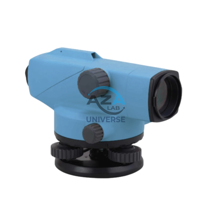
AUTOMATIC LEVEL AZA1031
AZA1031 Automatic Level (Auto Level / Optical Level)
The AZA1031 Automatic Level is a precision optical leveling instrument engineered for accurate elevation measurement in surveying, construction layout, and civil engineering projects. Designed for durability and long-term accuracy, it delivers consistent performance in demanding outdoor environments while remaining simple and efficient to operate.
Reliable Self-Leveling Performance
At the core of the AZA1031 is a magnetic damping compensator that automatically corrects minor tilts and vibrations. This self-leveling mechanism ensures a stable horizontal line of sight without continuous manual adjustment, significantly reducing setup time and operator error.
Once roughly leveled using the circular bubble vial, the internal compensator completes the leveling process automatically, making the instrument ideal for long-distance and repetitive leveling tasks.
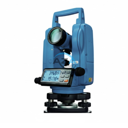
ELECTRONIC THEODOLITE AZA1027
Precision Redefined for Field Surveying
The AZA1027 is an essential instrument for topographic surveys, construction layout, and structural alignment. Equipped with high-resolution angle encoders, it significantly reduces reading errors and ensures consistent measurement accuracy.
An integrated optical plummet and dual-axis compensator allow reliable operation even on uneven terrain. With angular accuracy ranging from ±2″ to ±5″ seconds (model dependent), the AZA1027 is ideal for projects requiring tight tolerances such as bridges, tunnels, and high-rise structures.
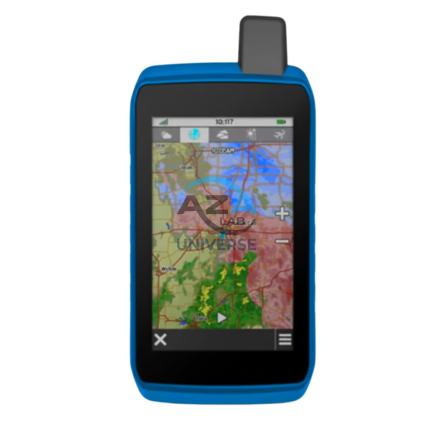
GPS SYSTEM AZA1039
AZA1039 GPS System (Professional GNSS Surveying Receiver)
The AZA1039 GPS System from Azalab is a high-performance, field-grade GNSS positioning solution engineered for land surveying, GIS mapping, construction layout, and geospatial data collection. Designed to deliver reliable accuracy in challenging environments, this system combines multi-constellation satellite tracking, real-time corrections, and rugged field durability.
Advanced Multi-Constellation GNSS Accuracy
Modern surveying demands precision beyond consumer-grade navigation devices. The AZA1039 utilizes multi-band GNSS technology, tracking multiple satellite constellations simultaneously, including:
-
GPS
-
GLONASS
-
Galileo
-
BeiDou
This ensures faster signal acquisition, higher positional reliability, and improved performance under tree canopy, near buildings, and in difficult terrain. When paired with RTK (Real-Time Kinematic) corrections, the system delivers centimeter-level accuracy, making it suitable for high-precision professional work.
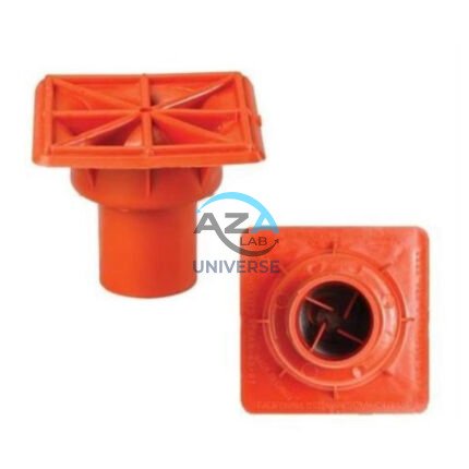
IMPALEMENT SAFETY COVERS AZA1023
Rebar Protection Solutions for Construction Site Safety & Compliance by Azalab
AZA1023 Impalement Safety Covers are critical safety components designed to protect workers, visitors, and pedestrians from impalement hazards caused by exposed reinforcement bars (rebars) on construction sites. These covers significantly reduce the risk of serious injury or fatal accidents while helping projects comply with mandatory safety regulations such as OSHA, BIS, and international construction safety standards.
At Azalab, safety is engineered into every detail. The AZA1023 range is developed to deliver high impact resistance, excellent visibility, easy installation, and long service life, making it an essential safety accessory for residential, commercial, and large-scale infrastructure projects
PRISM WITH POLE AZA1036
High-Precision Reflector for EDM Measurements
At the core of the AZA1036 is a single retroreflective survey prism, manufactured from high-purity optical glass and silver-coated for maximum signal return. The prism efficiently reflects the EDM signal back to the total station, enabling accurate distance measurement over long ranges—up to 2,000 meters, depending on instrument capability and site conditions. The prism is housed in a rugged protective casing and mounted on a high-visibility target plate, allowing easy acquisition through the telescope even in low-light, foggy, or dusty environments.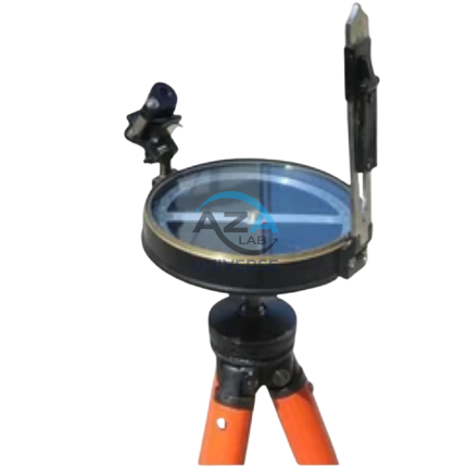
PRISMATIC COMPASS AZA1043
The Prismatic Compass AZA1043 from Azalab is a professional-grade navigation and surveying instrument designed for land surveying, geological exploration, mapping, and field navigation. Built for accuracy, durability, and ease of use, this compass is widely relied upon by surveyors, geologists, civil engineers, military personnel, students, and outdoor professionals operating in diverse and challenging environments.
Unlike conventional magnetic compasses, the prismatic compass incorporates an optical prism system that allows the user to simultaneously sight a distant object and read the bearing. This unique feature significantly improves measurement accuracy, particularly for long-distance bearings, triangulation, and route alignment tasks
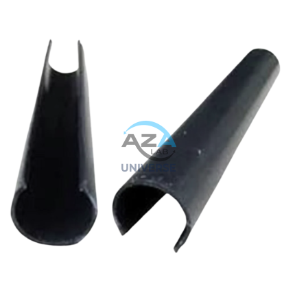
SCAFFOLD POLY CLIP AZA1019
Secure Fastening Solution for Debris Netting & Protective Mesh by Azalab
AZA1019 Scaffold Poly Clips are essential construction safety accessories designed for the secure fastening of debris netting, shade mesh, and protective sheeting to scaffolding structures. Engineered for durability, safety, and ease of use, these clips provide a tool-free, reusable, and weather-resistant fixing solution for construction and industrial sites.
Widely used by builders, safety officers, scaffolding contractors, and site supervisors, AZA1019 clips help improve site safety, dust control, and environmental protection at height.
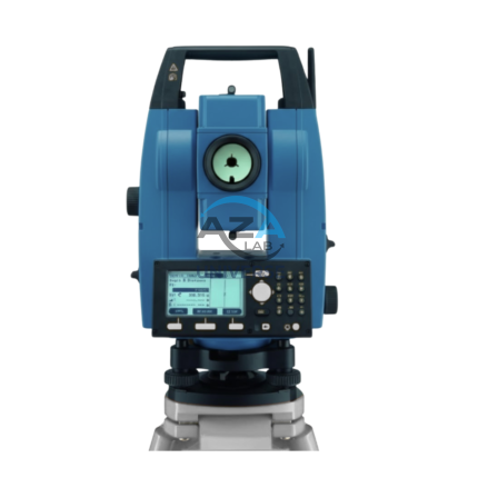
TOTAL STATION BUILDER AZA1029
AZA1029 Total Station Builder
The AZA1029 Total Station Builder is a high-precision digital surveying instrument engineered for construction layout, topographic surveying, and leveling applications. Combining an electronic theodolite, advanced EDM technology, and integrated survey software into a single rugged platform, AZA1029 delivers accuracy, efficiency, and reliability for demanding field environments.
Designed specifically for civil engineers, surveyors, and construction professionals, the AZA1029 ensures fast, repeatable, and highly accurate positioning across complex job sites.